You are here: Home > Network List > US - United States National Seismic Network Stations List
> Station WMOK Wichita Mountains, Oklahoma, USA > Earthquake Result Viewer
WMOK Wichita Mountains, Oklahoma, USA - Earthquake Result Viewer
| Earthquake location: |
Near Coast Of Central Chile |
| Earthquake latitude/longitude: |
-34.3/-71.9 |
| Earthquake time(UTC): |
2010/03/11 (070) 14:39:43 GMT |
| Earthquake Depth: |
11 km |
| Earthquake Magnitude: |
6.7 MB, 7.0 MS, 6.9 MW, 6.9 MW |
| Earthquake Catalog/Contributor: |
WHDF/NEIC |
|
| Network: |
US United States National Seismic Network |
| Station: |
WMOK Wichita Mountains, Oklahoma, USA |
| Lat/Lon: |
34.74 N/98.78 W |
| Elevation: |
486 m |
|
| Distance: |
73.1 deg |
| Az: |
337.095 deg |
| Baz: |
156.966 deg |
| Ray Param: |
0.053197905 |
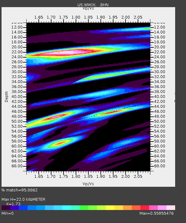
| Estimated Moho Depth: |
22.0 km |
| Estimated Crust Vp/Vs: |
1.73 |
| Assumed Crust Vp: |
6.315 km/s |
| Estimated Crust Vs: |
3.65 km/s |
| Estimated Crust Poisson's Ratio: |
0.25 |
|
| Radial Match: |
95.8862 % |
| Radial Bump: |
400 |
| Transverse Match: |
87.68112 % |
| Transverse Bump: |
400 |
| SOD ConfigId: |
299721 |
| Insert Time: |
2010-04-26 22:38:23.704 +0000 |
| GWidth: |
2.5 |
| Max Bumps: |
400 |
| Tol: |
0.001 |
|

Signal To Noise
| Channel | StoN | STA | LTA |
| US:WMOK: :BHZ:20100311T14:50:43.100024Z | 12.095043 | 2.642145E-6 | 2.1844858E-7 |
| US:WMOK: :BHN:20100311T14:50:43.100024Z | 3.904957 | 1.0016242E-6 | 2.565007E-7 |
| US:WMOK: :BHE:20100311T14:50:43.100024Z | 1.1487687 | 2.6829568E-7 | 2.3355067E-7 |
| Arrivals |
| Ps | 2.6 SECOND |
| PpPs | 9.2 SECOND |
| PsPs/PpSs | 12 SECOND |


