You are here: Home > Network List > US - United States National Seismic Network Stations List
> Station WMOK Wichita Mountains, Oklahoma, USA > Earthquake Result Viewer
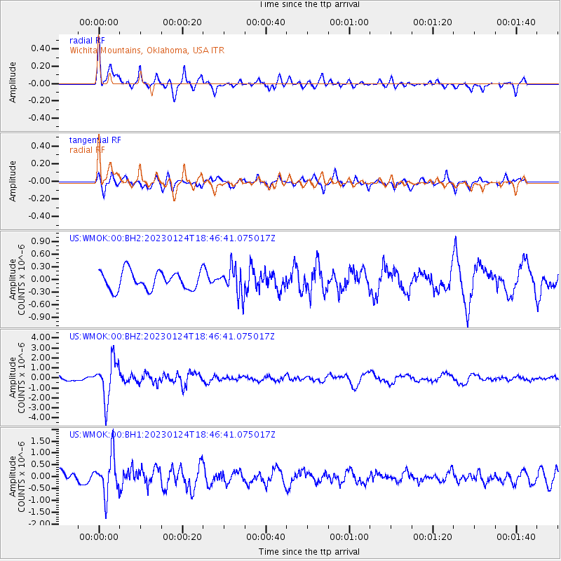
WMOK Wichita Mountains, Oklahoma, USA - Earthquake Result Viewer
*The percent match for this event was below the threshold and hence no stack was calculated.
| Earthquake location: |
Santiago Del Estero Prov., Arg. |
| Earthquake latitude/longitude: |
-26.7/-63.1 |
| Earthquake time(UTC): |
2023/01/24 (024) 18:37:00 GMT |
| Earthquake Depth: |
596 km |
| Earthquake Magnitude: |
6.4 mww |
| Earthquake Catalog/Contributor: |
NEIC PDE/us |
|
| Network: |
US United States National Seismic Network |
| Station: |
WMOK Wichita Mountains, Oklahoma, USA |
| Lat/Lon: |
34.74 N/98.78 W |
| Elevation: |
486 m |
|
| Distance: |
69.8 deg |
| Az: |
329.238 deg |
| Baz: |
146.261 deg |
| Ray Param: |
$rayparam |
*The percent match for this event was below the threshold and hence was not used in the summary stack. |
|
| Radial Match: |
71.01714 % |
| Radial Bump: |
394 |
| Transverse Match: |
68.88006 % |
| Transverse Bump: |
400 |
| SOD ConfigId: |
29823551 |
| Insert Time: |
2023-02-07 19:06:51.440 +0000 |
| GWidth: |
2.5 |
| Max Bumps: |
400 |
| Tol: |
0.001 |
|
Signal To Noise
| Channel | StoN | STA | LTA |
| US:WMOK:00:BHZ:20230124T18:46:41.075017Z | 6.7718267 | 2.0170712E-6 | 2.978622E-7 |
| US:WMOK:00:BH1:20230124T18:46:41.075017Z | 3.2826624 | 8.4548907E-7 | 2.57562E-7 |
| US:WMOK:00:BH2:20230124T18:46:41.075017Z | 1.5777557 | 3.38122E-7 | 2.1430569E-7 |
| Arrivals |
| Ps | |
| PpPs | |
| PsPs/PpSs | |


