You are here: Home > Network List > TA - USArray Transportable Network (new EarthScope stations) Stations List
> Station O25A Wiggins, CO, USA > Earthquake Result Viewer
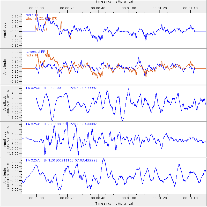
O25A Wiggins, CO, USA - Earthquake Result Viewer
*The percent match for this event was below the threshold and hence no stack was calculated.
| Earthquake location: |
Near Coast Of Central Chile |
| Earthquake latitude/longitude: |
-34.3/-71.8 |
| Earthquake time(UTC): |
2010/03/11 (070) 14:55:27 GMT |
| Earthquake Depth: |
18 km |
| Earthquake Magnitude: |
6.5 MB, 6.7 MW |
| Earthquake Catalog/Contributor: |
WHDF/NEIC |
|
| Network: |
TA USArray Transportable Network (new EarthScope stations) |
| Station: |
O25A Wiggins, CO, USA |
| Lat/Lon: |
40.11 N/104.12 W |
| Elevation: |
1444 m |
|
| Distance: |
79.9 deg |
| Az: |
335.382 deg |
| Baz: |
153.285 deg |
| Ray Param: |
$rayparam |
*The percent match for this event was below the threshold and hence was not used in the summary stack. |
|
| Radial Match: |
66.43766 % |
| Radial Bump: |
400 |
| Transverse Match: |
66.90342 % |
| Transverse Bump: |
394 |
| SOD ConfigId: |
299721 |
| Insert Time: |
2010-04-26 22:56:34.182 +0000 |
| GWidth: |
2.5 |
| Max Bumps: |
400 |
| Tol: |
0.001 |
|
Signal To Noise
| Channel | StoN | STA | LTA |
| TA:O25A: :BHZ:20100311T15:07:03.49999Z | 1.8336856 | 2.134771E-6 | 1.1641969E-6 |
| TA:O25A: :BHN:20100311T15:07:03.49999Z | 1.8219987 | 4.9061073E-6 | 2.6927062E-6 |
| TA:O25A: :BHE:20100311T15:07:03.49999Z | 0.7653767 | 2.2550705E-6 | 2.9463538E-6 |
| Arrivals |
| Ps | |
| PpPs | |
| PsPs/PpSs | |


