You are here: Home > Network List > TA - USArray Transportable Network (new EarthScope stations) Stations List
> Station G21A Lodge Grass, MT, USA > Earthquake Result Viewer
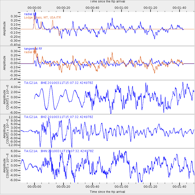
G21A Lodge Grass, MT, USA - Earthquake Result Viewer
*The percent match for this event was below the threshold and hence no stack was calculated.
| Earthquake location: |
Near Coast Of Central Chile |
| Earthquake latitude/longitude: |
-34.3/-71.8 |
| Earthquake time(UTC): |
2010/03/11 (070) 14:55:27 GMT |
| Earthquake Depth: |
18 km |
| Earthquake Magnitude: |
6.5 MB, 6.7 MW |
| Earthquake Catalog/Contributor: |
WHDF/NEIC |
|
| Network: |
TA USArray Transportable Network (new EarthScope stations) |
| Station: |
G21A Lodge Grass, MT, USA |
| Lat/Lon: |
45.22 N/107.21 W |
| Elevation: |
1227 m |
|
| Distance: |
85.4 deg |
| Az: |
335.746 deg |
| Baz: |
151.245 deg |
| Ray Param: |
$rayparam |
*The percent match for this event was below the threshold and hence was not used in the summary stack. |
|
| Radial Match: |
58.00381 % |
| Radial Bump: |
400 |
| Transverse Match: |
41.846447 % |
| Transverse Bump: |
400 |
| SOD ConfigId: |
299721 |
| Insert Time: |
2010-04-26 22:57:18.680 +0000 |
| GWidth: |
2.5 |
| Max Bumps: |
400 |
| Tol: |
0.001 |
|
Signal To Noise
| Channel | StoN | STA | LTA |
| TA:G21A: :BHZ:20100311T15:07:32.424978Z | 3.9077003 | 4.497033E-6 | 1.1508131E-6 |
| TA:G21A: :BHN:20100311T15:07:32.424978Z | 0.65331334 | 1.2098551E-6 | 1.8518756E-6 |
| TA:G21A: :BHE:20100311T15:07:32.424978Z | 0.8159774 | 2.1040355E-6 | 2.5785464E-6 |
| Arrivals |
| Ps | |
| PpPs | |
| PsPs/PpSs | |


