You are here: Home > Network List > AU - Australian Seismological Centre Stations List
> Station WB2 Warramunga Array, Australia > Earthquake Result Viewer
WB2 Warramunga Array, Australia - Earthquake Result Viewer
| Earthquake location: |
Kermadec Islands, New Zealand |
| Earthquake latitude/longitude: |
-30.2/-178.7 |
| Earthquake time(UTC): |
2023/01/26 (026) 10:45:52 GMT |
| Earthquake Depth: |
131 km |
| Earthquake Magnitude: |
6.0 mww |
| Earthquake Catalog/Contributor: |
NEIC PDE/us |
|
| Network: |
AU Australian Seismological Centre |
| Station: |
WB2 Warramunga Array, Australia |
| Lat/Lon: |
19.94 S/134.35 E |
| Elevation: |
388 m |
|
| Distance: |
43.5 deg |
| Az: |
272.338 deg |
| Baz: |
113.187 deg |
| Ray Param: |
0.07205193 |
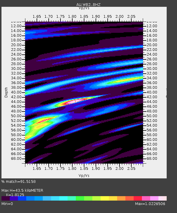
| Estimated Moho Depth: |
43.5 km |
| Estimated Crust Vp/Vs: |
1.81 |
| Assumed Crust Vp: |
6.642 km/s |
| Estimated Crust Vs: |
3.665 km/s |
| Estimated Crust Poisson's Ratio: |
0.28 |
|
| Radial Match: |
91.5158 % |
| Radial Bump: |
345 |
| Transverse Match: |
88.58932 % |
| Transverse Bump: |
400 |
| SOD ConfigId: |
29823551 |
| Insert Time: |
2023-02-09 10:48:47.248 +0000 |
| GWidth: |
2.5 |
| Max Bumps: |
400 |
| Tol: |
0.001 |
|

Signal To Noise
| Channel | StoN | STA | LTA |
| AU:WB2: :BHZ:20230126T10:53:12.799996Z | 28.509937 | 1.0833794E-6 | 3.8000064E-8 |
| AU:WB2: :BHN:20230126T10:53:12.799996Z | 7.280493 | 2.7940962E-7 | 3.8377845E-8 |
| AU:WB2: :BHE:20230126T10:53:12.799996Z | 16.157143 | 5.6549356E-7 | 3.4999605E-8 |
| Arrivals |
| Ps | 5.7 SECOND |
| PpPs | 17 SECOND |
| PsPs/PpSs | 23 SECOND |


