You are here: Home > Network List > TA - USArray Transportable Network (new EarthScope stations) Stations List
> Station N27A Anderson Farm, Haxtun, CO, USA > Earthquake Result Viewer
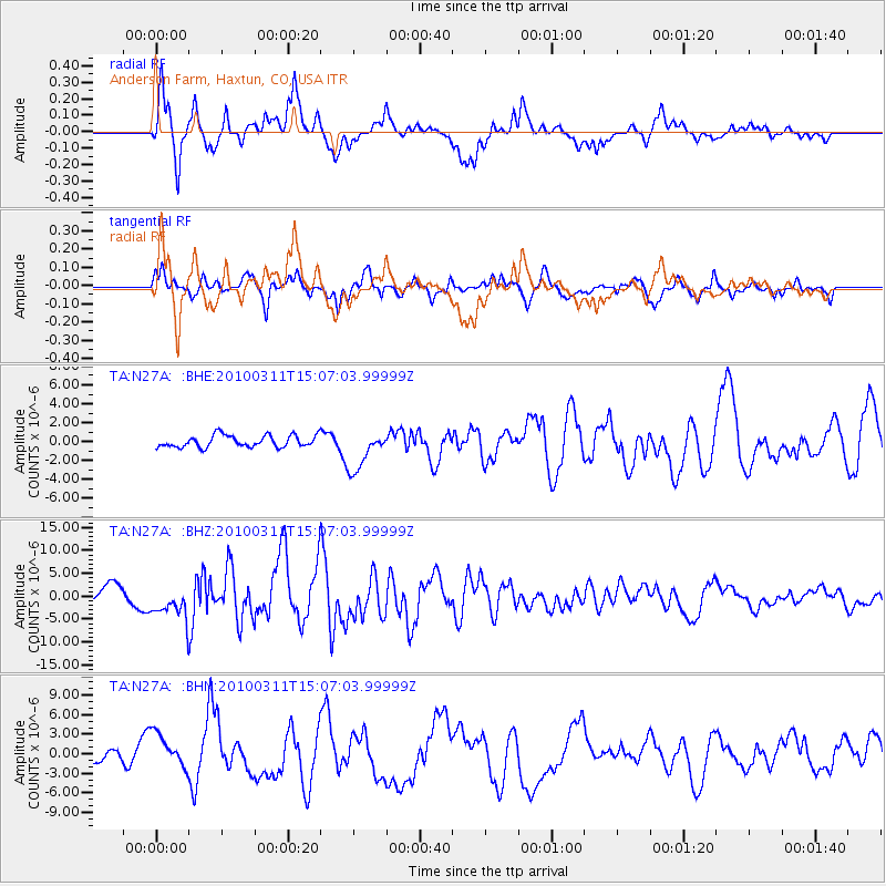
N27A Anderson Farm, Haxtun, CO, USA - Earthquake Result Viewer
*The percent match for this event was below the threshold and hence no stack was calculated.
| Earthquake location: |
Near Coast Of Central Chile |
| Earthquake latitude/longitude: |
-34.3/-71.8 |
| Earthquake time(UTC): |
2010/03/11 (070) 14:55:27 GMT |
| Earthquake Depth: |
18 km |
| Earthquake Magnitude: |
6.5 MB, 6.7 MW |
| Earthquake Catalog/Contributor: |
WHDF/NEIC |
|
| Network: |
TA USArray Transportable Network (new EarthScope stations) |
| Station: |
N27A Anderson Farm, Haxtun, CO, USA |
| Lat/Lon: |
40.81 N/102.54 W |
| Elevation: |
1228 m |
|
| Distance: |
79.9 deg |
| Az: |
336.793 deg |
| Baz: |
154.556 deg |
| Ray Param: |
$rayparam |
*The percent match for this event was below the threshold and hence was not used in the summary stack. |
|
| Radial Match: |
61.712418 % |
| Radial Bump: |
369 |
| Transverse Match: |
66.168465 % |
| Transverse Bump: |
377 |
| SOD ConfigId: |
299721 |
| Insert Time: |
2010-04-26 23:04:11.912 +0000 |
| GWidth: |
2.5 |
| Max Bumps: |
400 |
| Tol: |
0.001 |
|
Signal To Noise
| Channel | StoN | STA | LTA |
| TA:N27A: :BHZ:20100311T15:07:03.99999Z | 2.0771327 | 3.8519065E-6 | 1.8544345E-6 |
| TA:N27A: :BHN:20100311T15:07:03.99999Z | 1.4782138 | 2.7297654E-6 | 1.8466649E-6 |
| TA:N27A: :BHE:20100311T15:07:03.99999Z | 3.486536 | 2.1746887E-6 | 6.23739E-7 |
| Arrivals |
| Ps | |
| PpPs | |
| PsPs/PpSs | |


