You are here: Home > Network List > US - United States National Seismic Network Stations List
> Station NEW Newport, Washington, USA > Earthquake Result Viewer
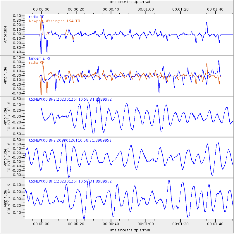
NEW Newport, Washington, USA - Earthquake Result Viewer
*The percent match for this event was below the threshold and hence no stack was calculated.
| Earthquake location: |
Kermadec Islands, New Zealand |
| Earthquake latitude/longitude: |
-30.2/-178.7 |
| Earthquake time(UTC): |
2023/01/26 (026) 10:45:52 GMT |
| Earthquake Depth: |
131 km |
| Earthquake Magnitude: |
6.0 mww |
| Earthquake Catalog/Contributor: |
NEIC PDE/us |
|
| Network: |
US United States National Seismic Network |
| Station: |
NEW Newport, Washington, USA |
| Lat/Lon: |
48.26 N/117.12 W |
| Elevation: |
760 m |
|
| Distance: |
95.6 deg |
| Az: |
36.18 deg |
| Baz: |
229.874 deg |
| Ray Param: |
$rayparam |
*The percent match for this event was below the threshold and hence was not used in the summary stack. |
|
| Radial Match: |
58.97025 % |
| Radial Bump: |
400 |
| Transverse Match: |
55.06494 % |
| Transverse Bump: |
400 |
| SOD ConfigId: |
29823551 |
| Insert Time: |
2023-02-09 11:01:39.061 +0000 |
| GWidth: |
2.5 |
| Max Bumps: |
400 |
| Tol: |
0.001 |
|
Signal To Noise
| Channel | StoN | STA | LTA |
| US:NEW:00:BHZ:20230126T10:58:31.898995Z | 0.9469294 | 2.9350247E-7 | 3.099518E-7 |
| US:NEW:00:BH1:20230126T10:58:31.898995Z | 0.7620451 | 1.6643838E-7 | 2.1841016E-7 |
| US:NEW:00:BH2:20230126T10:58:31.898995Z | 2.5145814 | 4.4977108E-7 | 1.7886519E-7 |
| Arrivals |
| Ps | |
| PpPs | |
| PsPs/PpSs | |


