You are here: Home > Network List > TA - USArray Transportable Network (new EarthScope stations) Stations List
> Station 431A Sonora, TX, USA > Earthquake Result Viewer
431A Sonora, TX, USA - Earthquake Result Viewer
| Earthquake location: |
Near Coast Of Central Chile |
| Earthquake latitude/longitude: |
-34.3/-71.8 |
| Earthquake time(UTC): |
2010/03/11 (070) 14:55:27 GMT |
| Earthquake Depth: |
18 km |
| Earthquake Magnitude: |
6.5 MB, 6.7 MW |
| Earthquake Catalog/Contributor: |
WHDF/NEIC |
|
| Network: |
TA USArray Transportable Network (new EarthScope stations) |
| Station: |
431A Sonora, TX, USA |
| Lat/Lon: |
30.68 N/100.61 W |
| Elevation: |
700 m |
|
| Distance: |
70.1 deg |
| Az: |
333.804 deg |
| Baz: |
154.908 deg |
| Ray Param: |
0.055165477 |
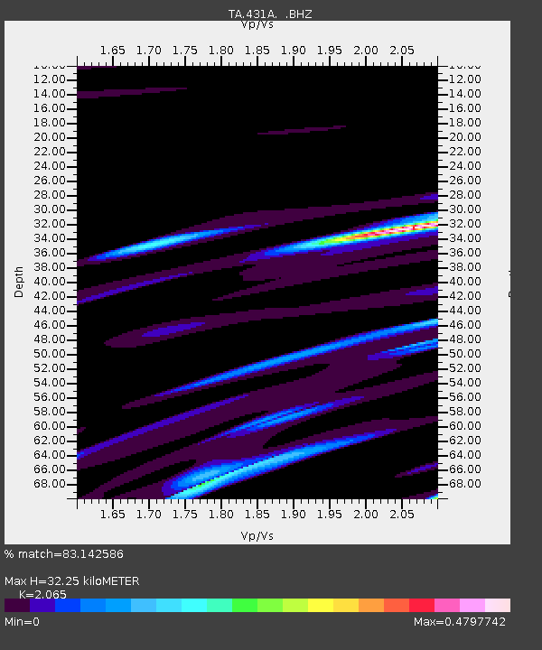
| Estimated Moho Depth: |
32.25 km |
| Estimated Crust Vp/Vs: |
2.07 |
| Assumed Crust Vp: |
6.38 km/s |
| Estimated Crust Vs: |
3.09 km/s |
| Estimated Crust Poisson's Ratio: |
0.35 |
|
| Radial Match: |
83.142586 % |
| Radial Bump: |
400 |
| Transverse Match: |
73.07817 % |
| Transverse Bump: |
358 |
| SOD ConfigId: |
299721 |
| Insert Time: |
2010-04-26 23:06:32.497 +0000 |
| GWidth: |
2.5 |
| Max Bumps: |
400 |
| Tol: |
0.001 |
|
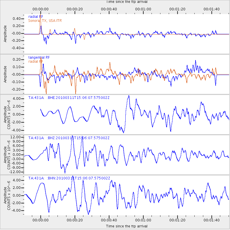
Signal To Noise
| Channel | StoN | STA | LTA |
| TA:431A: :BHZ:20100311T15:06:07.575002Z | 2.948246 | 2.7060692E-6 | 9.178572E-7 |
| TA:431A: :BHN:20100311T15:06:07.575002Z | 2.582189 | 2.860813E-6 | 1.1079022E-6 |
| TA:431A: :BHE:20100311T15:06:07.575002Z | 1.4595883 | 1.6081843E-6 | 1.1018069E-6 |
| Arrivals |
| Ps | 5.6 SECOND |
| PpPs | 15 SECOND |
| PsPs/PpSs | 21 SECOND |


