You are here: Home > Network List > UW - Pacific Northwest Regional Seismic Network Stations List
> Station HOOD Mt Hood Meadows, OR CREST BB SMO > Earthquake Result Viewer
HOOD Mt Hood Meadows, OR CREST BB SMO - Earthquake Result Viewer
*The percent match for this event was below the threshold and hence no stack was calculated.
| Earthquake location: |
Turkey-Iran Border Region |
| Earthquake latitude/longitude: |
38.4/44.9 |
| Earthquake time(UTC): |
2023/01/28 (028) 18:14:44 GMT |
| Earthquake Depth: |
10 km |
| Earthquake Magnitude: |
5.9 mww |
| Earthquake Catalog/Contributor: |
NEIC PDE/us |
|
| Network: |
UW Pacific Northwest Regional Seismic Network |
| Station: |
HOOD Mt Hood Meadows, OR CREST BB SMO |
| Lat/Lon: |
45.32 N/121.65 W |
| Elevation: |
1520 m |
|
| Distance: |
95.8 deg |
| Az: |
350.508 deg |
| Baz: |
10.579 deg |
| Ray Param: |
$rayparam |
*The percent match for this event was below the threshold and hence was not used in the summary stack. |
|
| Radial Match: |
40.705666 % |
| Radial Bump: |
400 |
| Transverse Match: |
41.430878 % |
| Transverse Bump: |
400 |
| SOD ConfigId: |
29823551 |
| Insert Time: |
2023-02-11 18:30:54.182 +0000 |
| GWidth: |
2.5 |
| Max Bumps: |
400 |
| Tol: |
0.001 |
|
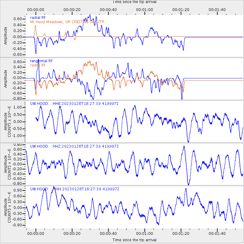
Signal To Noise
| Channel | StoN | STA | LTA |
| UW:HOOD: :HHZ:20230128T18:27:39.419997Z | 1.0504038 | 2.6020038E-7 | 2.477146E-7 |
| UW:HOOD: :HHN:20230128T18:27:39.419997Z | 2.1963942 | 6.8176723E-7 | 3.1040292E-7 |
| UW:HOOD: :HHE:20230128T18:27:39.419997Z | 0.7431798 | 3.8808977E-7 | 5.2220173E-7 |
| Arrivals |
| Ps | |
| PpPs | |
| PsPs/PpSs | |


