You are here: Home > Network List > TA - USArray Transportable Network (new EarthScope stations) Stations List
> Station S29A Ulysses, KS, USA > Earthquake Result Viewer
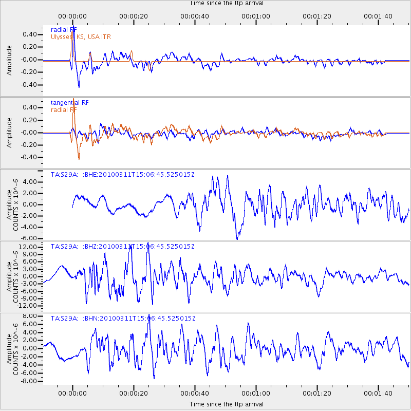
S29A Ulysses, KS, USA - Earthquake Result Viewer
*The percent match for this event was below the threshold and hence no stack was calculated.
| Earthquake location: |
Near Coast Of Central Chile |
| Earthquake latitude/longitude: |
-34.3/-71.8 |
| Earthquake time(UTC): |
2010/03/11 (070) 14:55:27 GMT |
| Earthquake Depth: |
18 km |
| Earthquake Magnitude: |
6.5 MB, 6.7 MW |
| Earthquake Catalog/Contributor: |
WHDF/NEIC |
|
| Network: |
TA USArray Transportable Network (new EarthScope stations) |
| Station: |
S29A Ulysses, KS, USA |
| Lat/Lon: |
37.62 N/101.12 W |
| Elevation: |
931 m |
|
| Distance: |
76.6 deg |
| Az: |
336.438 deg |
| Baz: |
155.378 deg |
| Ray Param: |
$rayparam |
*The percent match for this event was below the threshold and hence was not used in the summary stack. |
|
| Radial Match: |
75.923775 % |
| Radial Bump: |
400 |
| Transverse Match: |
53.10762 % |
| Transverse Bump: |
400 |
| SOD ConfigId: |
299721 |
| Insert Time: |
2010-04-26 23:07:54.855 +0000 |
| GWidth: |
2.5 |
| Max Bumps: |
400 |
| Tol: |
0.001 |
|
Signal To Noise
| Channel | StoN | STA | LTA |
| TA:S29A: :BHZ:20100311T15:06:45.525015Z | 1.9142536 | 3.2649768E-6 | 1.7056136E-6 |
| TA:S29A: :BHN:20100311T15:06:45.525015Z | 0.6977723 | 1.7083913E-6 | 2.4483509E-6 |
| TA:S29A: :BHE:20100311T15:06:45.525015Z | 1.3164973 | 1.4437941E-6 | 1.0966934E-6 |
| Arrivals |
| Ps | |
| PpPs | |
| PsPs/PpSs | |


