You are here: Home > Network List > TA - USArray Transportable Network (new EarthScope stations) Stations List
> Station S30A Montezuma, KS, USA > Earthquake Result Viewer
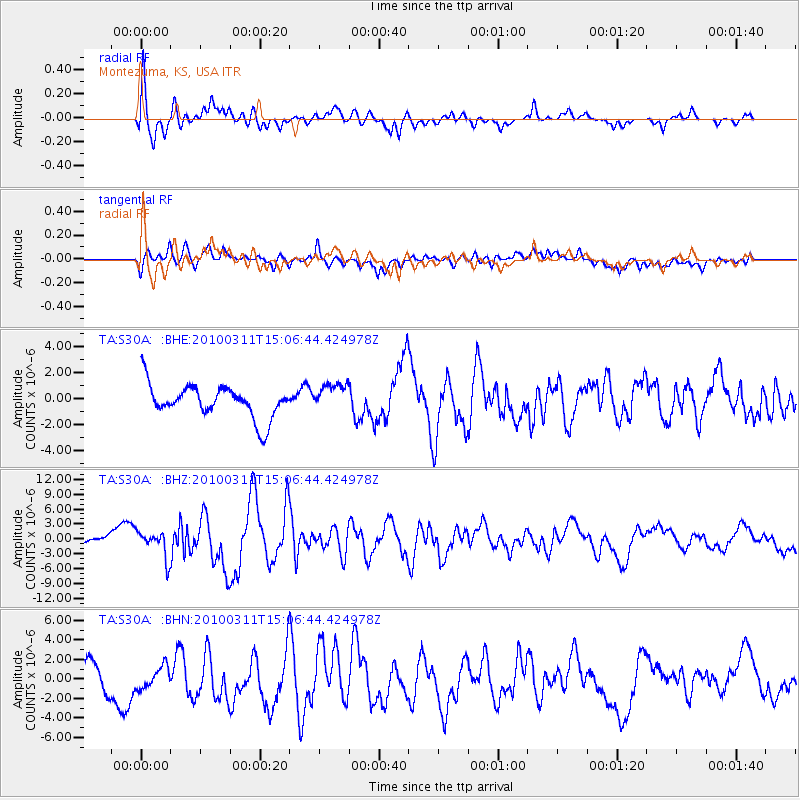
S30A Montezuma, KS, USA - Earthquake Result Viewer
*The percent match for this event was below the threshold and hence no stack was calculated.
| Earthquake location: |
Near Coast Of Central Chile |
| Earthquake latitude/longitude: |
-34.3/-71.8 |
| Earthquake time(UTC): |
2010/03/11 (070) 14:55:27 GMT |
| Earthquake Depth: |
18 km |
| Earthquake Magnitude: |
6.5 MB, 6.7 MW |
| Earthquake Catalog/Contributor: |
WHDF/NEIC |
|
| Network: |
TA USArray Transportable Network (new EarthScope stations) |
| Station: |
S30A Montezuma, KS, USA |
| Lat/Lon: |
37.64 N/100.46 W |
| Elevation: |
853 m |
|
| Distance: |
76.4 deg |
| Az: |
336.933 deg |
| Baz: |
155.891 deg |
| Ray Param: |
$rayparam |
*The percent match for this event was below the threshold and hence was not used in the summary stack. |
|
| Radial Match: |
69.90717 % |
| Radial Bump: |
400 |
| Transverse Match: |
60.131435 % |
| Transverse Bump: |
400 |
| SOD ConfigId: |
299721 |
| Insert Time: |
2010-04-26 23:08:26.154 +0000 |
| GWidth: |
2.5 |
| Max Bumps: |
400 |
| Tol: |
0.001 |
|
Signal To Noise
| Channel | StoN | STA | LTA |
| TA:S30A: :BHZ:20100311T15:06:44.424978Z | 1.9941719 | 2.6339806E-6 | 1.3208393E-6 |
| TA:S30A: :BHN:20100311T15:06:44.424978Z | 0.47409782 | 1.1110657E-6 | 2.3435368E-6 |
| TA:S30A: :BHE:20100311T15:06:44.424978Z | 0.8875058 | 1.1301786E-6 | 1.2734322E-6 |
| Arrivals |
| Ps | |
| PpPs | |
| PsPs/PpSs | |


