You are here: Home > Network List > TA - USArray Transportable Network (new EarthScope stations) Stations List
> Station U28A Mallet, Rita Blanca National Grassland, TX, USA > Earthquake Result Viewer
U28A Mallet, Rita Blanca National Grassland, TX, USA - Earthquake Result Viewer

| Earthquake location: |
Near Coast Of Central Chile |
| Earthquake latitude/longitude: |
-34.3/-71.8 |
| Earthquake time(UTC): |
2010/03/11 (070) 14:55:27 GMT |
| Earthquake Depth: |
18 km |
| Earthquake Magnitude: |
6.5 MB, 6.7 MW |
| Earthquake Catalog/Contributor: |
WHDF/NEIC |
|
| Network: |
TA USArray Transportable Network (new EarthScope stations) |
| Station: |
U28A Mallet, Rita Blanca National Grassland, TX, USA |
| Lat/Lon: |
36.38 N/102.22 W |
| Elevation: |
1165 m |
|
| Distance: |
75.9 deg |
| Az: |
335.071 deg |
| Baz: |
154.389 deg |
| Ray Param: |
0.051374532 |
| Estimated Moho Depth: |
48.0 km |
| Estimated Crust Vp/Vs: |
1.74 |
| Assumed Crust Vp: |
6.306 km/s |
| Estimated Crust Vs: |
3.624 km/s |
| Estimated Crust Poisson's Ratio: |
0.25 |
|
| Radial Match: |
82.510376 % |
| Radial Bump: |
400 |
| Transverse Match: |
56.041515 % |
| Transverse Bump: |
397 |
| SOD ConfigId: |
299721 |
| Insert Time: |
2010-04-26 23:08:39.375 +0000 |
| GWidth: |
2.5 |
| Max Bumps: |
400 |
| Tol: |
0.001 |
|
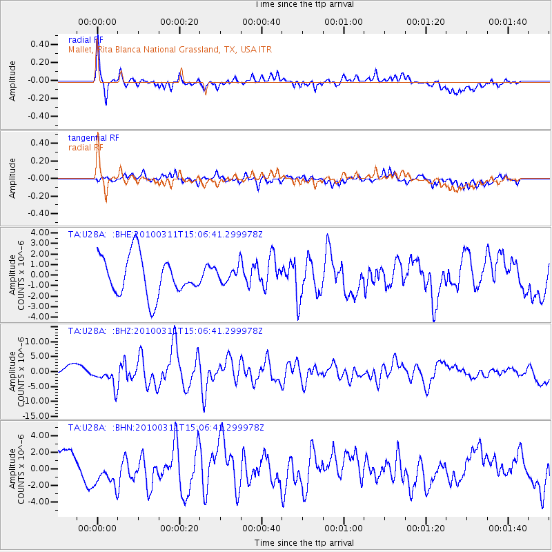
Signal To Noise
| Channel | StoN | STA | LTA |
| TA:U28A: :BHZ:20100311T15:06:41.299978Z | 3.117679 | 3.5957273E-6 | 1.1533347E-6 |
| TA:U28A: :BHN:20100311T15:06:41.299978Z | 1.2266601 | 1.8422915E-6 | 1.501876E-6 |
| TA:U28A: :BHE:20100311T15:06:41.299978Z | 0.4151784 | 7.7198627E-7 | 1.8594085E-6 |
| Arrivals |
| Ps | 5.8 SECOND |
| PpPs | 20 SECOND |
| PsPs/PpSs | 26 SECOND |


