You are here: Home > Network List > TA - USArray Transportable Network (new EarthScope stations) Stations List
> Station Q30A Quinter, KS, USA > Earthquake Result Viewer
Q30A Quinter, KS, USA - Earthquake Result Viewer

| Earthquake location: |
Near Coast Of Central Chile |
| Earthquake latitude/longitude: |
-34.3/-71.8 |
| Earthquake time(UTC): |
2010/03/11 (070) 14:55:27 GMT |
| Earthquake Depth: |
18 km |
| Earthquake Magnitude: |
6.5 MB, 6.7 MW |
| Earthquake Catalog/Contributor: |
WHDF/NEIC |
|
| Network: |
TA USArray Transportable Network (new EarthScope stations) |
| Station: |
Q30A Quinter, KS, USA |
| Lat/Lon: |
38.98 N/100.22 W |
| Elevation: |
797 m |
|
| Distance: |
77.5 deg |
| Az: |
337.669 deg |
| Baz: |
156.207 deg |
| Ray Param: |
0.050236106 |
| Estimated Moho Depth: |
69.75 km |
| Estimated Crust Vp/Vs: |
1.74 |
| Assumed Crust Vp: |
6.483 km/s |
| Estimated Crust Vs: |
3.72 km/s |
| Estimated Crust Poisson's Ratio: |
0.25 |
|
| Radial Match: |
83.84828 % |
| Radial Bump: |
400 |
| Transverse Match: |
63.106102 % |
| Transverse Bump: |
400 |
| SOD ConfigId: |
299721 |
| Insert Time: |
2010-04-26 23:09:27.133 +0000 |
| GWidth: |
2.5 |
| Max Bumps: |
400 |
| Tol: |
0.001 |
|
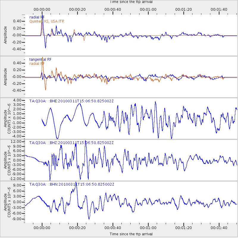
Signal To Noise
| Channel | StoN | STA | LTA |
| TA:Q30A: :BHZ:20100311T15:06:50.825002Z | 1.7350384 | 4.187247E-6 | 2.4133456E-6 |
| TA:Q30A: :BHN:20100311T15:06:50.825002Z | 1.2887272 | 1.8826521E-6 | 1.4608617E-6 |
| TA:Q30A: :BHE:20100311T15:06:50.825002Z | 0.5998674 | 1.1282281E-6 | 1.8807957E-6 |
| Arrivals |
| Ps | 8.2 SECOND |
| PpPs | 29 SECOND |
| PsPs/PpSs | 37 SECOND |


