You are here: Home > Network List > TA - USArray Transportable Network (new EarthScope stations) Stations List
> Station A27A Ledoux Ranch, Antler, ND, USA > Earthquake Result Viewer
A27A Ledoux Ranch, Antler, ND, USA - Earthquake Result Viewer
| Earthquake location: |
Near Coast Of Central Chile |
| Earthquake latitude/longitude: |
-34.3/-71.8 |
| Earthquake time(UTC): |
2010/03/11 (070) 14:55:27 GMT |
| Earthquake Depth: |
18 km |
| Earthquake Magnitude: |
6.5 MB, 6.7 MW |
| Earthquake Catalog/Contributor: |
WHDF/NEIC |
|
| Network: |
TA USArray Transportable Network (new EarthScope stations) |
| Station: |
A27A Ledoux Ranch, Antler, ND, USA |
| Lat/Lon: |
48.95 N/101.24 W |
| Elevation: |
466 m |
|
| Distance: |
87.0 deg |
| Az: |
341.065 deg |
| Baz: |
155.958 deg |
| Ray Param: |
0.043655593 |
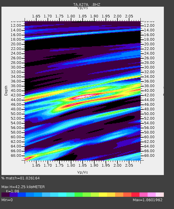
| Estimated Moho Depth: |
42.25 km |
| Estimated Crust Vp/Vs: |
1.86 |
| Assumed Crust Vp: |
6.438 km/s |
| Estimated Crust Vs: |
3.461 km/s |
| Estimated Crust Poisson's Ratio: |
0.30 |
|
| Radial Match: |
81.826164 % |
| Radial Bump: |
400 |
| Transverse Match: |
60.91945 % |
| Transverse Bump: |
382 |
| SOD ConfigId: |
299721 |
| Insert Time: |
2010-04-26 23:14:41.328 +0000 |
| GWidth: |
2.5 |
| Max Bumps: |
400 |
| Tol: |
0.001 |
|

Signal To Noise
| Channel | StoN | STA | LTA |
| TA:A27A: :BHZ:20100311T15:07:39.900015Z | 7.102395 | 5.493758E-6 | 7.7350785E-7 |
| TA:A27A: :BHN:20100311T15:07:39.900015Z | 0.53573596 | 1.1697587E-6 | 2.183461E-6 |
| TA:A27A: :BHE:20100311T15:07:39.900015Z | 0.60168254 | 8.5451387E-7 | 1.4202071E-6 |
| Arrivals |
| Ps | 5.8 SECOND |
| PpPs | 18 SECOND |
| PsPs/PpSs | 24 SECOND |


