You are here: Home > Network List > TA - USArray Transportable Network (new EarthScope stations) Stations List
> Station E29A Napoleon, ND, USA > Earthquake Result Viewer
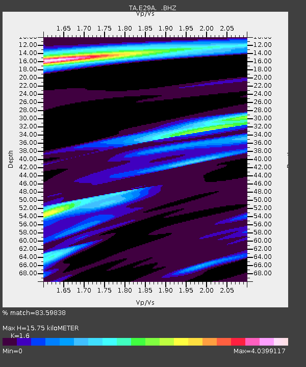
E29A Napoleon, ND, USA - Earthquake Result Viewer
| Earthquake location: |
Near Coast Of Central Chile |
| Earthquake latitude/longitude: |
-34.3/-71.8 |
| Earthquake time(UTC): |
2010/03/11 (070) 14:55:27 GMT |
| Earthquake Depth: |
18 km |
| Earthquake Magnitude: |
6.5 MB, 6.7 MW |
| Earthquake Catalog/Contributor: |
WHDF/NEIC |
|
| Network: |
TA USArray Transportable Network (new EarthScope stations) |
| Station: |
E29A Napoleon, ND, USA |
| Lat/Lon: |
46.57 N/99.64 W |
| Elevation: |
628 m |
|
| Distance: |
84.3 deg |
| Az: |
341.105 deg |
| Baz: |
157.141 deg |
| Ray Param: |
0.045537245 |
| Estimated Moho Depth: |
15.75 km |
| Estimated Crust Vp/Vs: |
1.60 |
| Assumed Crust Vp: |
6.53 km/s |
| Estimated Crust Vs: |
4.082 km/s |
| Estimated Crust Poisson's Ratio: |
0.18 |
|
| Radial Match: |
83.59838 % |
| Radial Bump: |
400 |
| Transverse Match: |
56.403324 % |
| Transverse Bump: |
352 |
| SOD ConfigId: |
299721 |
| Insert Time: |
2010-04-26 23:15:17.530 +0000 |
| GWidth: |
2.5 |
| Max Bumps: |
400 |
| Tol: |
0.001 |
|

Signal To Noise
| Channel | StoN | STA | LTA |
| TA:E29A: :BHZ:20100311T15:07:26.950002Z | 5.8398895 | 4.5420497E-6 | 7.77763E-7 |
| TA:E29A: :BHN:20100311T15:07:26.950002Z | 1.2718933 | 2.7404003E-6 | 2.1545834E-6 |
| TA:E29A: :BHE:20100311T15:07:26.950002Z | 0.7177576 | 2.0204773E-6 | 2.8149857E-6 |
| Arrivals |
| Ps | 1.5 SECOND |
| PpPs | 6.1 SECOND |
| PsPs/PpSs | 7.6 SECOND |


