You are here: Home > Network List > TA - USArray Transportable Network (new EarthScope stations) Stations List
> Station O31A Woollen Ranch, Alma, NE, USA > Earthquake Result Viewer
O31A Woollen Ranch, Alma, NE, USA - Earthquake Result Viewer
| Earthquake location: |
Near Coast Of Central Chile |
| Earthquake latitude/longitude: |
-34.3/-71.8 |
| Earthquake time(UTC): |
2010/03/11 (070) 14:55:27 GMT |
| Earthquake Depth: |
18 km |
| Earthquake Magnitude: |
6.5 MB, 6.7 MW |
| Earthquake Catalog/Contributor: |
WHDF/NEIC |
|
| Network: |
TA USArray Transportable Network (new EarthScope stations) |
| Station: |
O31A Woollen Ranch, Alma, NE, USA |
| Lat/Lon: |
40.15 N/99.33 W |
| Elevation: |
631 m |
|
| Distance: |
78.3 deg |
| Az: |
338.794 deg |
| Baz: |
157.01 deg |
| Ray Param: |
0.049689725 |
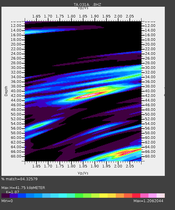
| Estimated Moho Depth: |
41.75 km |
| Estimated Crust Vp/Vs: |
1.87 |
| Assumed Crust Vp: |
6.53 km/s |
| Estimated Crust Vs: |
3.492 km/s |
| Estimated Crust Poisson's Ratio: |
0.30 |
|
| Radial Match: |
84.32579 % |
| Radial Bump: |
400 |
| Transverse Match: |
60.22604 % |
| Transverse Bump: |
400 |
| SOD ConfigId: |
299721 |
| Insert Time: |
2010-04-26 23:16:43.237 +0000 |
| GWidth: |
2.5 |
| Max Bumps: |
400 |
| Tol: |
0.001 |
|
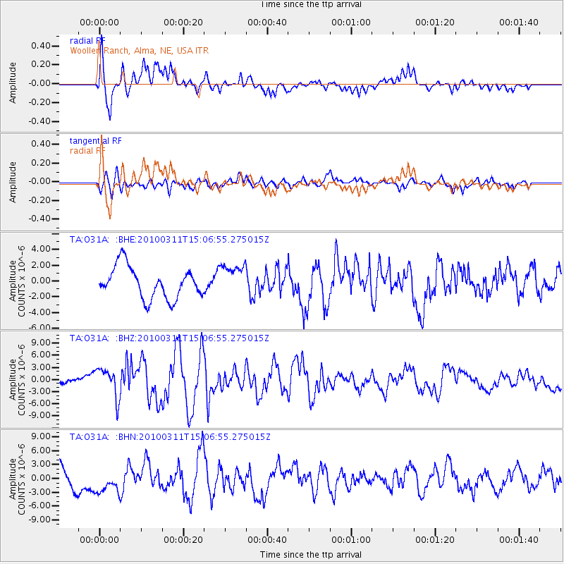
Signal To Noise
| Channel | StoN | STA | LTA |
| TA:O31A: :BHZ:20100311T15:06:55.275015Z | 1.6545372 | 3.7181455E-6 | 2.247242E-6 |
| TA:O31A: :BHN:20100311T15:06:55.275015Z | 0.9996973 | 2.732648E-6 | 2.7334752E-6 |
| TA:O31A: :BHE:20100311T15:06:55.275015Z | 1.0222088 | 2.0198088E-6 | 1.975926E-6 |
| Arrivals |
| Ps | 5.7 SECOND |
| PpPs | 18 SECOND |
| PsPs/PpSs | 24 SECOND |


