You are here: Home > Network List > AU - Australian Seismological Centre Stations List
> Station KLGGI Kalgoorlie Hampton Hill, WA, GSWA > Earthquake Result Viewer
KLGGI Kalgoorlie Hampton Hill, WA, GSWA - Earthquake Result Viewer
| Earthquake location: |
Mindanao, Philippines |
| Earthquake latitude/longitude: |
7.7/126.1 |
| Earthquake time(UTC): |
2023/02/01 (032) 10:44:44 GMT |
| Earthquake Depth: |
9.4 km |
| Earthquake Magnitude: |
6.0 mww |
| Earthquake Catalog/Contributor: |
NEIC PDE/us |
|
| Network: |
AU Australian Seismological Centre |
| Station: |
KLGGI Kalgoorlie Hampton Hill, WA, GSWA |
| Lat/Lon: |
30.28 S/121.76 E |
| Elevation: |
385 m |
|
| Distance: |
38.0 deg |
| Az: |
186.055 deg |
| Baz: |
6.941 deg |
| Ray Param: |
0.07580262 |
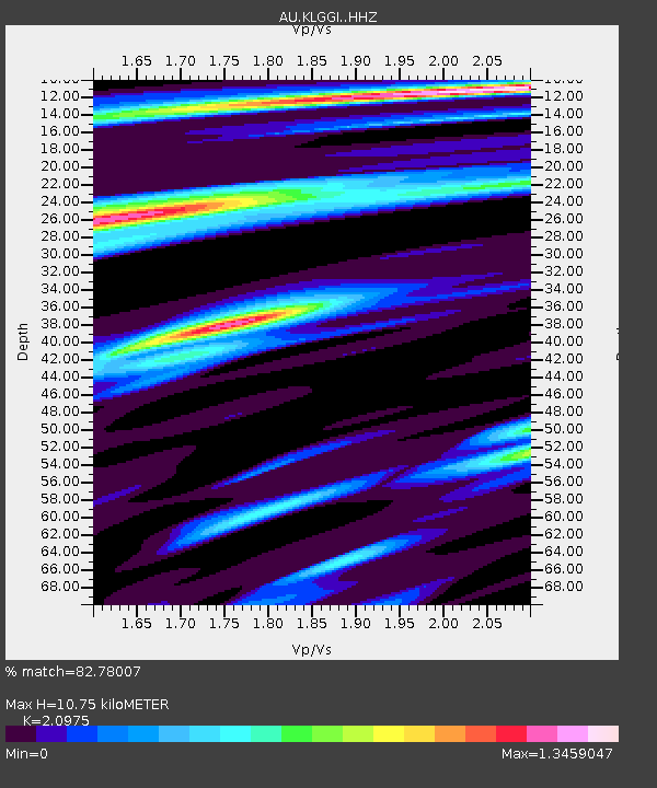
| Estimated Moho Depth: |
10.75 km |
| Estimated Crust Vp/Vs: |
2.10 |
| Assumed Crust Vp: |
6.459 km/s |
| Estimated Crust Vs: |
3.08 km/s |
| Estimated Crust Poisson's Ratio: |
0.35 |
|
| Radial Match: |
82.78007 % |
| Radial Bump: |
358 |
| Transverse Match: |
50.542667 % |
| Transverse Bump: |
400 |
| SOD ConfigId: |
29823551 |
| Insert Time: |
2023-02-15 10:49:52.050 +0000 |
| GWidth: |
2.5 |
| Max Bumps: |
400 |
| Tol: |
0.001 |
|

Signal To Noise
| Channel | StoN | STA | LTA |
| AU:KLGGI: :HHZ:20230201T10:51:32.019999Z | 3.0027864 | 1.9239048E-6 | 6.4070656E-7 |
| AU:KLGGI: :HHN:20230201T10:51:32.019999Z | 2.7604663 | 1.2498535E-6 | 4.5276897E-7 |
| AU:KLGGI: :HHE:20230201T10:51:32.019999Z | 1.6418637 | 4.3144112E-7 | 2.6277522E-7 |
| Arrivals |
| Ps | 1.9 SECOND |
| PpPs | 4.8 SECOND |
| PsPs/PpSs | 6.8 SECOND |


