You are here: Home > Network List > TA - USArray Transportable Network (new EarthScope stations) Stations List
> Station P33A Williams Farm, Concordia, KS, USA > Earthquake Result Viewer
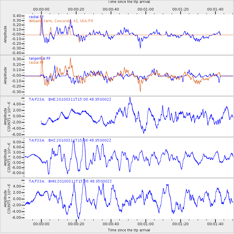
P33A Williams Farm, Concordia, KS, USA - Earthquake Result Viewer
*The percent match for this event was below the threshold and hence no stack was calculated.
| Earthquake location: |
Near Coast Of Central Chile |
| Earthquake latitude/longitude: |
-34.3/-71.8 |
| Earthquake time(UTC): |
2010/03/11 (070) 14:55:27 GMT |
| Earthquake Depth: |
18 km |
| Earthquake Magnitude: |
6.5 MB, 6.7 MW |
| Earthquake Catalog/Contributor: |
WHDF/NEIC |
|
| Network: |
TA USArray Transportable Network (new EarthScope stations) |
| Station: |
P33A Williams Farm, Concordia, KS, USA |
| Lat/Lon: |
39.44 N/97.69 W |
| Elevation: |
488 m |
|
| Distance: |
77.2 deg |
| Az: |
339.705 deg |
| Baz: |
158.243 deg |
| Ray Param: |
$rayparam |
*The percent match for this event was below the threshold and hence was not used in the summary stack. |
|
| Radial Match: |
64.242966 % |
| Radial Bump: |
400 |
| Transverse Match: |
78.36058 % |
| Transverse Bump: |
400 |
| SOD ConfigId: |
299721 |
| Insert Time: |
2010-04-26 23:17:27.108 +0000 |
| GWidth: |
2.5 |
| Max Bumps: |
400 |
| Tol: |
0.001 |
|
Signal To Noise
| Channel | StoN | STA | LTA |
| TA:P33A: :BHZ:20100311T15:06:48.950002Z | 1.812511 | 4.1478365E-6 | 2.2884476E-6 |
| TA:P33A: :BHN:20100311T15:06:48.950002Z | 0.6315211 | 1.8709736E-6 | 2.9626462E-6 |
| TA:P33A: :BHE:20100311T15:06:48.950002Z | 0.94442385 | 1.3545871E-6 | 1.4343E-6 |
| Arrivals |
| Ps | |
| PpPs | |
| PsPs/PpSs | |


