You are here: Home > Network List > AV - Alaska Volcano Observatory Stations List
> Station MAPS Pakushin Southeast, Makushin Volcano, Alaska > Earthquake Result Viewer
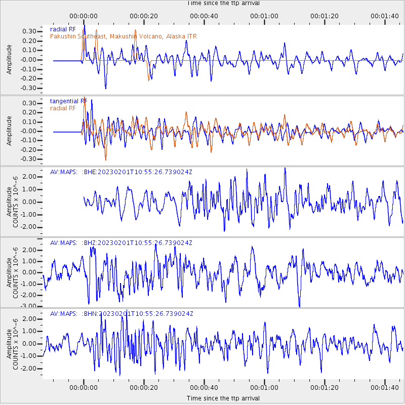
MAPS Pakushin Southeast, Makushin Volcano, Alaska - Earthquake Result Viewer
*The percent match for this event was below the threshold and hence no stack was calculated.
| Earthquake location: |
Mindanao, Philippines |
| Earthquake latitude/longitude: |
7.7/126.1 |
| Earthquake time(UTC): |
2023/02/01 (032) 10:44:44 GMT |
| Earthquake Depth: |
9.4 km |
| Earthquake Magnitude: |
6.0 mww |
| Earthquake Catalog/Contributor: |
NEIC PDE/us |
|
| Network: |
AV Alaska Volcano Observatory |
| Station: |
MAPS Pakushin Southeast, Makushin Volcano, Alaska |
| Lat/Lon: |
53.81 N/166.94 W |
| Elevation: |
333 m |
|
| Distance: |
70.3 deg |
| Az: |
35.443 deg |
| Baz: |
255.695 deg |
| Ray Param: |
$rayparam |
*The percent match for this event was below the threshold and hence was not used in the summary stack. |
|
| Radial Match: |
53.069855 % |
| Radial Bump: |
400 |
| Transverse Match: |
53.90164 % |
| Transverse Bump: |
400 |
| SOD ConfigId: |
29823551 |
| Insert Time: |
2023-02-15 10:51:50.409 +0000 |
| GWidth: |
2.5 |
| Max Bumps: |
400 |
| Tol: |
0.001 |
|
Signal To Noise
| Channel | StoN | STA | LTA |
| AV:MAPS: :BHZ:20230201T10:55:26.739024Z | 2.633175 | 1.5986096E-6 | 6.0710346E-7 |
| AV:MAPS: :BHN:20230201T10:55:26.739024Z | 1.16443 | 7.301186E-7 | 6.27018E-7 |
| AV:MAPS: :BHE:20230201T10:55:26.739024Z | 1.3639224 | 8.303337E-7 | 6.087837E-7 |
| Arrivals |
| Ps | |
| PpPs | |
| PsPs/PpSs | |


