You are here: Home > Network List > TA - USArray Transportable Network (new EarthScope stations) Stations List
> Station U34A Anderson Ranch, Garber, OK, USA > Earthquake Result Viewer
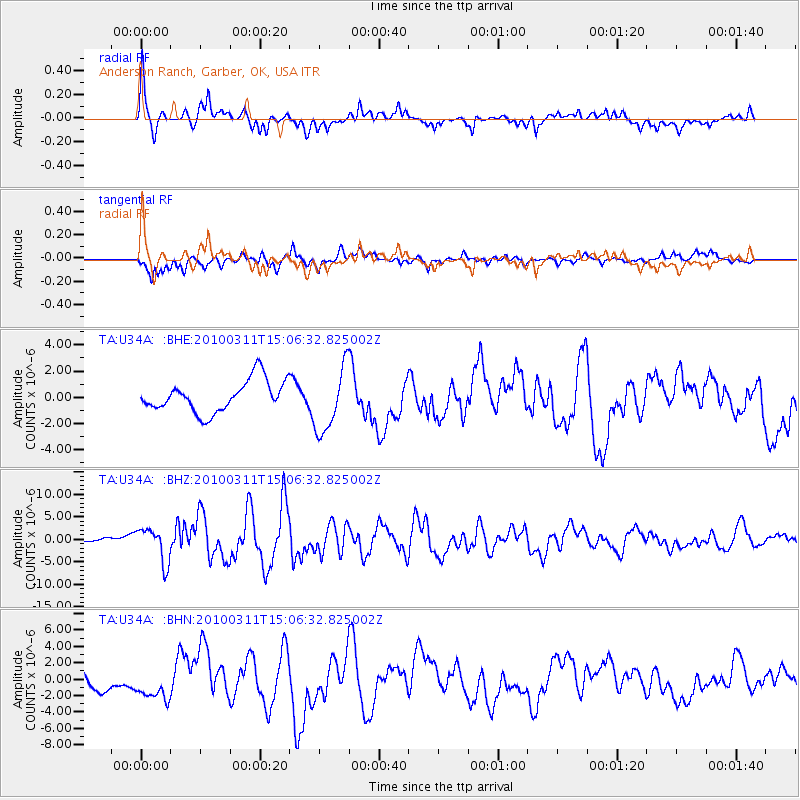
U34A Anderson Ranch, Garber, OK, USA - Earthquake Result Viewer
| Earthquake location: |
Near Coast Of Central Chile |
| Earthquake latitude/longitude: |
-34.3/-71.8 |
| Earthquake time(UTC): |
2010/03/11 (070) 14:55:27 GMT |
| Earthquake Depth: |
18 km |
| Earthquake Magnitude: |
6.5 MB, 6.7 MW |
| Earthquake Catalog/Contributor: |
WHDF/NEIC |
|
| Network: |
TA USArray Transportable Network (new EarthScope stations) |
| Station: |
U34A Anderson Ranch, Garber, OK, USA |
| Lat/Lon: |
36.44 N/97.54 W |
| Elevation: |
345 m |
|
| Distance: |
74.4 deg |
| Az: |
338.677 deg |
| Baz: |
158.088 deg |
| Ray Param: |
0.052357644 |
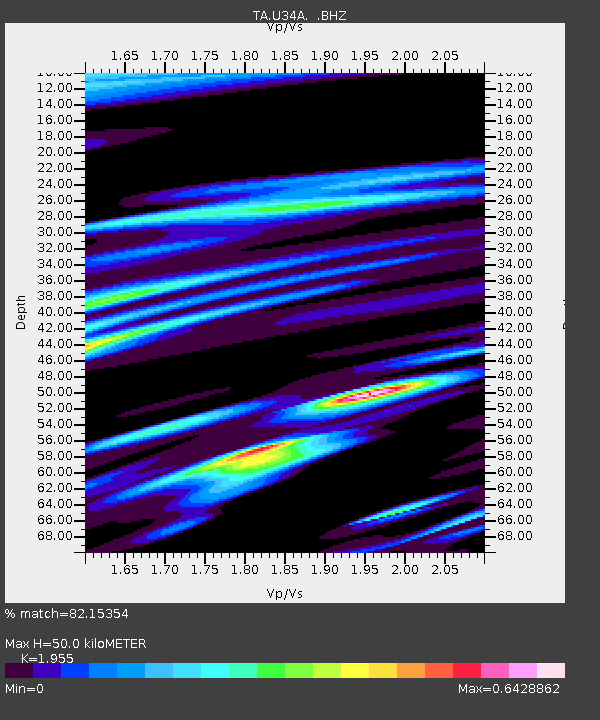
| Estimated Moho Depth: |
50.0 km |
| Estimated Crust Vp/Vs: |
1.96 |
| Assumed Crust Vp: |
6.483 km/s |
| Estimated Crust Vs: |
3.316 km/s |
| Estimated Crust Poisson's Ratio: |
0.32 |
|
| Radial Match: |
82.15354 % |
| Radial Bump: |
332 |
| Transverse Match: |
64.25928 % |
| Transverse Bump: |
365 |
| SOD ConfigId: |
299721 |
| Insert Time: |
2010-04-26 23:17:55.082 +0000 |
| GWidth: |
2.5 |
| Max Bumps: |
400 |
| Tol: |
0.001 |
|
Signal To Noise
| Channel | StoN | STA | LTA |
| TA:U34A: :BHZ:20100311T15:06:32.825002Z | 2.1634612 | 3.854732E-6 | 1.7817431E-6 |
| TA:U34A: :BHN:20100311T15:06:32.825002Z | 2.0136132 | 1.8599582E-6 | 9.236919E-7 |
| TA:U34A: :BHE:20100311T15:06:32.825002Z | 2.0856178 | 2.4962133E-6 | 1.1968699E-6 |
| Arrivals |
| Ps | 7.6 SECOND |
| PpPs | 22 SECOND |
| PsPs/PpSs | 30 SECOND |


