You are here: Home > Network List > TA - USArray Transportable Network (new EarthScope stations) Stations List
> Station U32A Winter Ranch, Mooreland, OK, USA > Earthquake Result Viewer
U32A Winter Ranch, Mooreland, OK, USA - Earthquake Result Viewer
| Earthquake location: |
Near Coast Of Central Chile |
| Earthquake latitude/longitude: |
-34.3/-71.8 |
| Earthquake time(UTC): |
2010/03/11 (070) 14:55:27 GMT |
| Earthquake Depth: |
18 km |
| Earthquake Magnitude: |
6.5 MB, 6.7 MW |
| Earthquake Catalog/Contributor: |
WHDF/NEIC |
|
| Network: |
TA USArray Transportable Network (new EarthScope stations) |
| Station: |
U32A Winter Ranch, Mooreland, OK, USA |
| Lat/Lon: |
36.38 N/99.00 W |
| Elevation: |
525 m |
|
| Distance: |
74.8 deg |
| Az: |
337.521 deg |
| Baz: |
156.914 deg |
| Ray Param: |
0.052088793 |
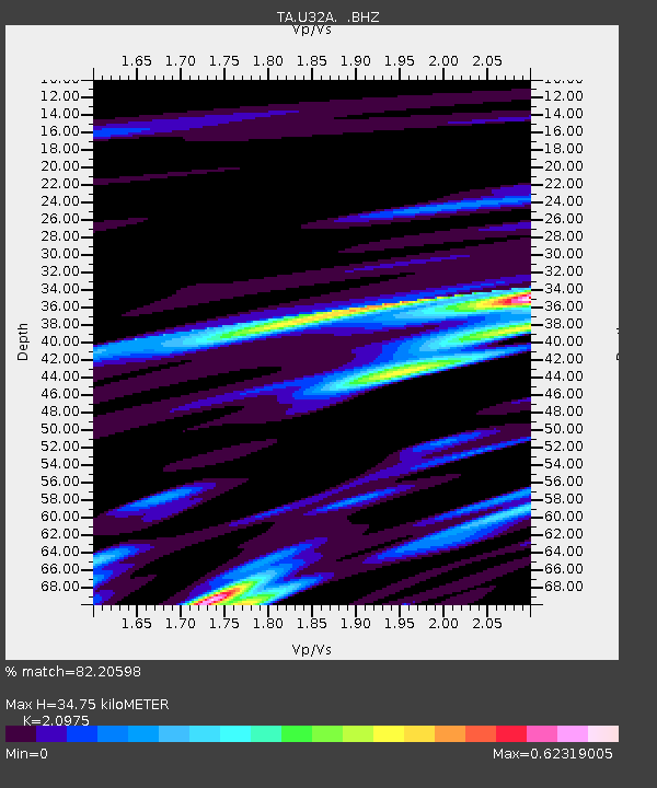
| Estimated Moho Depth: |
34.75 km |
| Estimated Crust Vp/Vs: |
2.10 |
| Assumed Crust Vp: |
6.426 km/s |
| Estimated Crust Vs: |
3.064 km/s |
| Estimated Crust Poisson's Ratio: |
0.35 |
|
| Radial Match: |
82.20598 % |
| Radial Bump: |
388 |
| Transverse Match: |
58.812088 % |
| Transverse Bump: |
400 |
| SOD ConfigId: |
299721 |
| Insert Time: |
2010-04-26 23:18:06.832 +0000 |
| GWidth: |
2.5 |
| Max Bumps: |
400 |
| Tol: |
0.001 |
|

Signal To Noise
| Channel | StoN | STA | LTA |
| TA:U32A: :BHZ:20100311T15:06:35.150015Z | 2.328029 | 3.5700145E-6 | 1.5334923E-6 |
| TA:U32A: :BHN:20100311T15:06:35.150015Z | 1.266473 | 1.5276606E-6 | 1.2062322E-6 |
| TA:U32A: :BHE:20100311T15:06:35.150015Z | 0.62658805 | 1.262558E-6 | 2.0149732E-6 |
| Arrivals |
| Ps | 6.1 SECOND |
| PpPs | 16 SECOND |
| PsPs/PpSs | 22 SECOND |


