You are here: Home > Network List > CN - Canadian National Seismograph Network Stations List
> Station INK INUVIK, NT > Earthquake Result Viewer
INK INUVIK, NT - Earthquake Result Viewer
*The percent match for this event was below the threshold and hence no stack was calculated.
| Earthquake location: |
Mindanao, Philippines |
| Earthquake latitude/longitude: |
7.7/126.1 |
| Earthquake time(UTC): |
2023/02/01 (032) 10:44:44 GMT |
| Earthquake Depth: |
9.4 km |
| Earthquake Magnitude: |
6.0 mww |
| Earthquake Catalog/Contributor: |
NEIC PDE/us |
|
| Network: |
CN Canadian National Seismograph Network |
| Station: |
INK INUVIK, NT |
| Lat/Lon: |
68.31 N/133.53 W |
| Elevation: |
44 m |
|
| Distance: |
86.7 deg |
| Az: |
21.486 deg |
| Baz: |
282.488 deg |
| Ray Param: |
$rayparam |
*The percent match for this event was below the threshold and hence was not used in the summary stack. |
|
| Radial Match: |
63.037262 % |
| Radial Bump: |
327 |
| Transverse Match: |
47.22039 % |
| Transverse Bump: |
355 |
| SOD ConfigId: |
29823551 |
| Insert Time: |
2023-02-15 10:53:29.376 +0000 |
| GWidth: |
2.5 |
| Max Bumps: |
400 |
| Tol: |
0.001 |
|
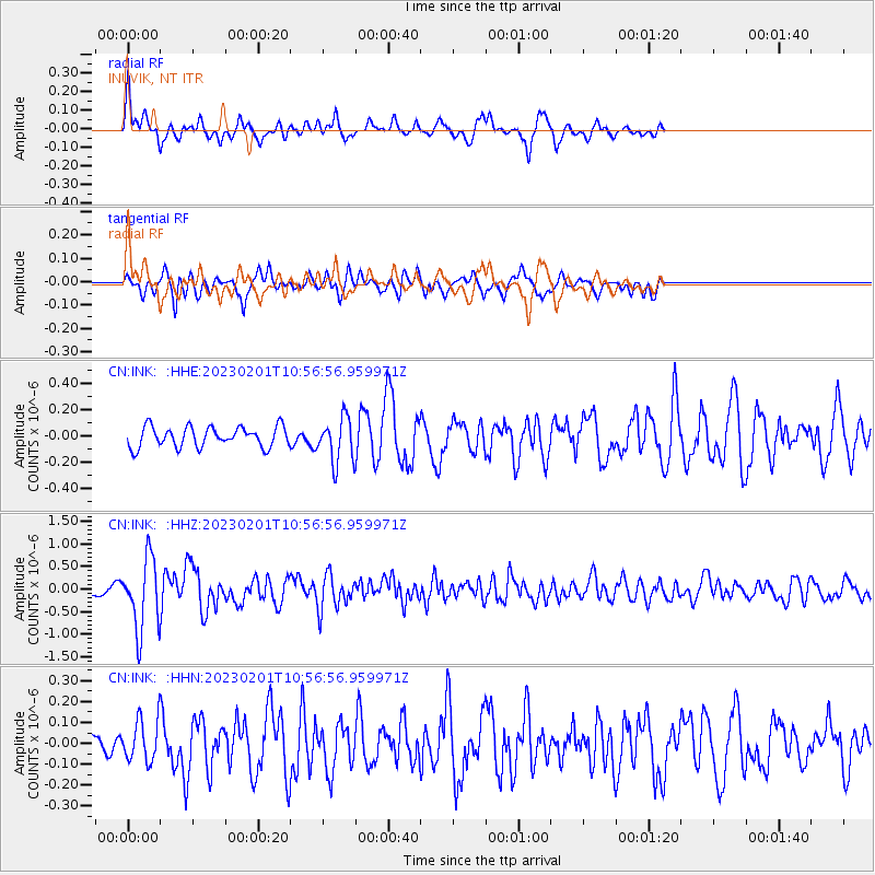
Signal To Noise
| Channel | StoN | STA | LTA |
| CN:INK: :HHZ:20230201T10:56:56.959971Z | 7.1325774 | 7.772164E-7 | 1.0896713E-7 |
| CN:INK: :HHN:20230201T10:56:56.959971Z | 0.81059873 | 9.66421E-8 | 1.192231E-7 |
| CN:INK: :HHE:20230201T10:56:56.959971Z | 2.16652 | 1.6780595E-7 | 7.745414E-8 |
| Arrivals |
| Ps | |
| PpPs | |
| PsPs/PpSs | |


