You are here: Home > Network List > TA - USArray Transportable Network (new EarthScope stations) Stations List
> Station 833A Chaparral WMA, Artesia Wells, TX, USA > Earthquake Result Viewer
833A Chaparral WMA, Artesia Wells, TX, USA - Earthquake Result Viewer
| Earthquake location: |
Near Coast Of Central Chile |
| Earthquake latitude/longitude: |
-34.3/-71.8 |
| Earthquake time(UTC): |
2010/03/11 (070) 14:55:27 GMT |
| Earthquake Depth: |
18 km |
| Earthquake Magnitude: |
6.5 MB, 6.7 MW |
| Earthquake Catalog/Contributor: |
WHDF/NEIC |
|
| Network: |
TA USArray Transportable Network (new EarthScope stations) |
| Station: |
833A Chaparral WMA, Artesia Wells, TX, USA |
| Lat/Lon: |
28.32 N/99.39 W |
| Elevation: |
171 m |
|
| Distance: |
67.6 deg |
| Az: |
333.777 deg |
| Baz: |
155.493 deg |
| Ray Param: |
0.056859978 |
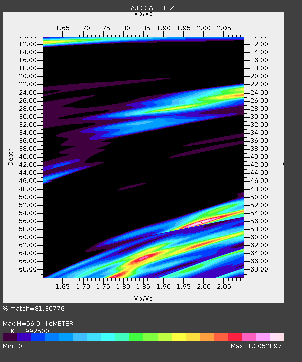
| Estimated Moho Depth: |
56.0 km |
| Estimated Crust Vp/Vs: |
1.99 |
| Assumed Crust Vp: |
6.347 km/s |
| Estimated Crust Vs: |
3.185 km/s |
| Estimated Crust Poisson's Ratio: |
0.33 |
|
| Radial Match: |
81.30776 % |
| Radial Bump: |
352 |
| Transverse Match: |
57.298584 % |
| Transverse Bump: |
298 |
| SOD ConfigId: |
299721 |
| Insert Time: |
2010-04-26 23:20:19.108 +0000 |
| GWidth: |
2.5 |
| Max Bumps: |
400 |
| Tol: |
0.001 |
|
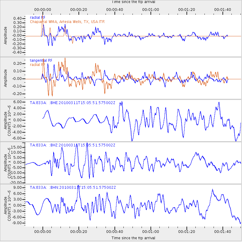
Signal To Noise
| Channel | StoN | STA | LTA |
| TA:833A: :BHZ:20100311T15:05:51.575002Z | 2.6726913 | 2.8388563E-6 | 1.0621713E-6 |
| TA:833A: :BHN:20100311T15:05:51.575002Z | 1.5692326 | 2.2903312E-6 | 1.4595231E-6 |
| TA:833A: :BHE:20100311T15:05:51.575002Z | 0.7397461 | 1.0175038E-6 | 1.375477E-6 |
| Arrivals |
| Ps | 9.1 SECOND |
| PpPs | 26 SECOND |
| PsPs/PpSs | 35 SECOND |


