You are here: Home > Network List > US - United States National Seismic Network Stations List
> Station LAO LASA Array, Montana, USA > Earthquake Result Viewer
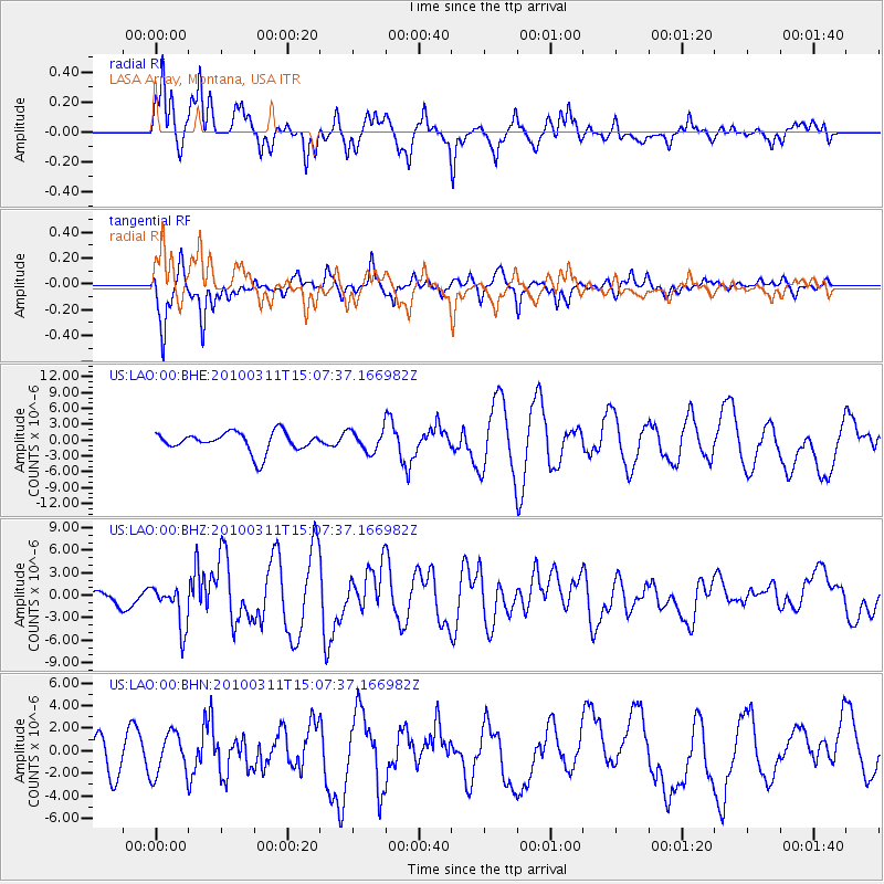
LAO LASA Array, Montana, USA - Earthquake Result Viewer
*The percent match for this event was below the threshold and hence no stack was calculated.
| Earthquake location: |
Near Coast Of Central Chile |
| Earthquake latitude/longitude: |
-34.3/-71.8 |
| Earthquake time(UTC): |
2010/03/11 (070) 14:55:27 GMT |
| Earthquake Depth: |
18 km |
| Earthquake Magnitude: |
6.5 MB, 6.7 MW |
| Earthquake Catalog/Contributor: |
WHDF/NEIC |
|
| Network: |
US United States National Seismic Network |
| Station: |
LAO LASA Array, Montana, USA |
| Lat/Lon: |
46.69 N/106.22 W |
| Elevation: |
902 m |
|
| Distance: |
86.4 deg |
| Az: |
337.048 deg |
| Baz: |
152.043 deg |
| Ray Param: |
$rayparam |
*The percent match for this event was below the threshold and hence was not used in the summary stack. |
|
| Radial Match: |
71.800285 % |
| Radial Bump: |
397 |
| Transverse Match: |
83.154564 % |
| Transverse Bump: |
400 |
| SOD ConfigId: |
299721 |
| Insert Time: |
2010-04-26 23:23:26.623 +0000 |
| GWidth: |
2.5 |
| Max Bumps: |
400 |
| Tol: |
0.001 |
|
Signal To Noise
| Channel | StoN | STA | LTA |
| US:LAO:00:BHZ:20100311T15:07:37.166982Z | 3.9144824 | 2.8797313E-6 | 7.356608E-7 |
| US:LAO:00:BHN:20100311T15:07:37.166982Z | 1.1006202 | 1.8586044E-6 | 1.6886884E-6 |
| US:LAO:00:BHE:20100311T15:07:37.166982Z | 1.0730321 | 1.9911995E-6 | 1.8556756E-6 |
| Arrivals |
| Ps | |
| PpPs | |
| PsPs/PpSs | |


