You are here: Home > Network List > AV - Alaska Volcano Observatory Stations List
> Station KARR Katmai Rainbow River, Alaska > Earthquake Result Viewer
KARR Katmai Rainbow River, Alaska - Earthquake Result Viewer
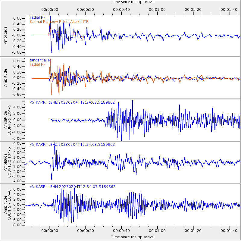
| Earthquake location: |
Eastern New Guinea Reg., P.N.G. |
| Earthquake latitude/longitude: |
-6.4/146.2 |
| Earthquake time(UTC): |
2023/02/04 (035) 12:22:36 GMT |
| Earthquake Depth: |
102 km |
| Earthquake Magnitude: |
5.7 mww |
| Earthquake Catalog/Contributor: |
NEIC PDE/us |
|
| Network: |
AV Alaska Volcano Observatory |
| Station: |
KARR Katmai Rainbow River, Alaska |
| Lat/Lon: |
58.50 N/154.71 W |
| Elevation: |
610 m |
|
| Distance: |
80.0 deg |
| Az: |
27.23 deg |
| Baz: |
240.004 deg |
| Ray Param: |
0.048364665 |
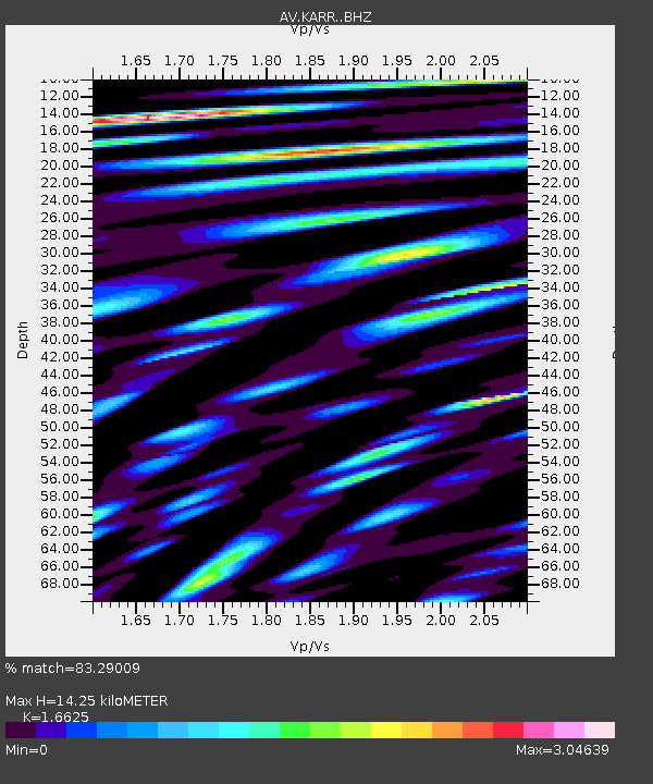
| Estimated Moho Depth: |
14.25 km |
| Estimated Crust Vp/Vs: |
1.66 |
| Assumed Crust Vp: |
6.438 km/s |
| Estimated Crust Vs: |
3.873 km/s |
| Estimated Crust Poisson's Ratio: |
0.22 |
|
| Radial Match: |
83.29009 % |
| Radial Bump: |
400 |
| Transverse Match: |
76.70838 % |
| Transverse Bump: |
400 |
| SOD ConfigId: |
29823551 |
| Insert Time: |
2023-02-18 12:28:19.698 +0000 |
| GWidth: |
2.5 |
| Max Bumps: |
400 |
| Tol: |
0.001 |
|
Signal To Noise
| Channel | StoN | STA | LTA |
| AV:KARR: :BHZ:20230204T12:34:03.518986Z | 8.501833 | 1.6730431E-6 | 1.9678617E-7 |
| AV:KARR: :BHN:20230204T12:34:03.518986Z | 6.8011537 | 1.5796063E-6 | 2.3225564E-7 |
| AV:KARR: :BHE:20230204T12:34:03.518986Z | 7.2106924 | 1.4902563E-6 | 2.0667312E-7 |
| Arrivals |
| Ps | 1.5 SECOND |
| PpPs | 5.7 SECOND |
| PsPs/PpSs | 7.2 SECOND |


