You are here: Home > Network List > UW - Pacific Northwest Regional Seismic Network Stations List
> Station LON Longmire CREST broad-band > Earthquake Result Viewer
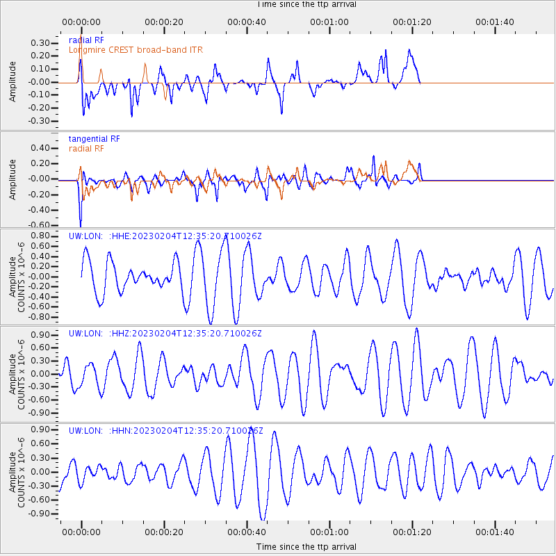
LON Longmire CREST broad-band - Earthquake Result Viewer
*The percent match for this event was below the threshold and hence no stack was calculated.
| Earthquake location: |
Eastern New Guinea Reg., P.N.G. |
| Earthquake latitude/longitude: |
-6.4/146.2 |
| Earthquake time(UTC): |
2023/02/04 (035) 12:22:36 GMT |
| Earthquake Depth: |
102 km |
| Earthquake Magnitude: |
5.7 mww |
| Earthquake Catalog/Contributor: |
NEIC PDE/us |
|
| Network: |
UW Pacific Northwest Regional Seismic Network |
| Station: |
LON Longmire CREST broad-band |
| Lat/Lon: |
46.75 N/121.81 W |
| Elevation: |
853 m |
|
| Distance: |
96.0 deg |
| Az: |
43.705 deg |
| Baz: |
267.074 deg |
| Ray Param: |
$rayparam |
*The percent match for this event was below the threshold and hence was not used in the summary stack. |
|
| Radial Match: |
53.8338 % |
| Radial Bump: |
350 |
| Transverse Match: |
68.026855 % |
| Transverse Bump: |
400 |
| SOD ConfigId: |
29823551 |
| Insert Time: |
2023-02-18 12:37:36.854 +0000 |
| GWidth: |
2.5 |
| Max Bumps: |
400 |
| Tol: |
0.001 |
|
Signal To Noise
| Channel | StoN | STA | LTA |
| UW:LON: :HHZ:20230204T12:35:20.710026Z | 0.71827567 | 2.590539E-7 | 3.6066083E-7 |
| UW:LON: :HHN:20230204T12:35:20.710026Z | 0.83976877 | 1.610903E-7 | 1.9182697E-7 |
| UW:LON: :HHE:20230204T12:35:20.710026Z | 2.114749 | 5.8226516E-7 | 2.7533537E-7 |
| Arrivals |
| Ps | |
| PpPs | |
| PsPs/PpSs | |


