You are here: Home > Network List > CI - Caltech Regional Seismic Network Stations List
> Station SWS Sam W. Stewart, Westmorland, CA, USA > Earthquake Result Viewer
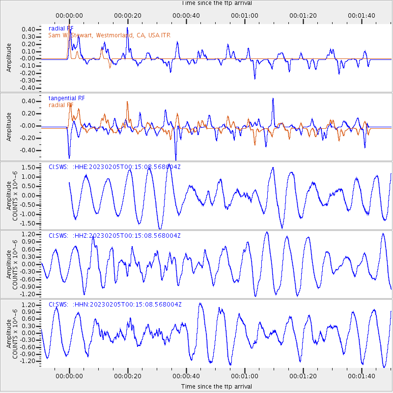
SWS Sam W. Stewart, Westmorland, CA, USA - Earthquake Result Viewer
*The percent match for this event was below the threshold and hence no stack was calculated.
| Earthquake location: |
Southeast Of Honshu, Japan |
| Earthquake latitude/longitude: |
32.7/141.8 |
| Earthquake time(UTC): |
2023/02/05 (036) 00:03:19 GMT |
| Earthquake Depth: |
10 km |
| Earthquake Magnitude: |
5.8 mww |
| Earthquake Catalog/Contributor: |
NEIC PDE/us |
|
| Network: |
CI Caltech Regional Seismic Network |
| Station: |
SWS Sam W. Stewart, Westmorland, CA, USA |
| Lat/Lon: |
32.94 N/115.80 W |
| Elevation: |
140 m |
|
| Distance: |
82.1 deg |
| Az: |
56.004 deg |
| Baz: |
303.741 deg |
| Ray Param: |
$rayparam |
*The percent match for this event was below the threshold and hence was not used in the summary stack. |
|
| Radial Match: |
39.12528 % |
| Radial Bump: |
356 |
| Transverse Match: |
58.49072 % |
| Transverse Bump: |
343 |
| SOD ConfigId: |
29823551 |
| Insert Time: |
2023-02-19 00:11:46.034 +0000 |
| GWidth: |
2.5 |
| Max Bumps: |
400 |
| Tol: |
0.001 |
|
Signal To Noise
| Channel | StoN | STA | LTA |
| CI:SWS: :HHZ:20230205T00:15:08.568004Z | 2.3265486 | 5.319231E-7 | 2.2863185E-7 |
| CI:SWS: :HHN:20230205T00:15:08.568004Z | 1.5389522 | 6.27026E-7 | 4.0743694E-7 |
| CI:SWS: :HHE:20230205T00:15:08.568004Z | 1.5262282 | 1.2644431E-6 | 8.284758E-7 |
| Arrivals |
| Ps | |
| PpPs | |
| PsPs/PpSs | |


