You are here: Home > Network List > TA - USArray Transportable Network (new EarthScope stations) Stations List
> Station T23A Casias Ranch, Antonito, CO, USA > Earthquake Result Viewer
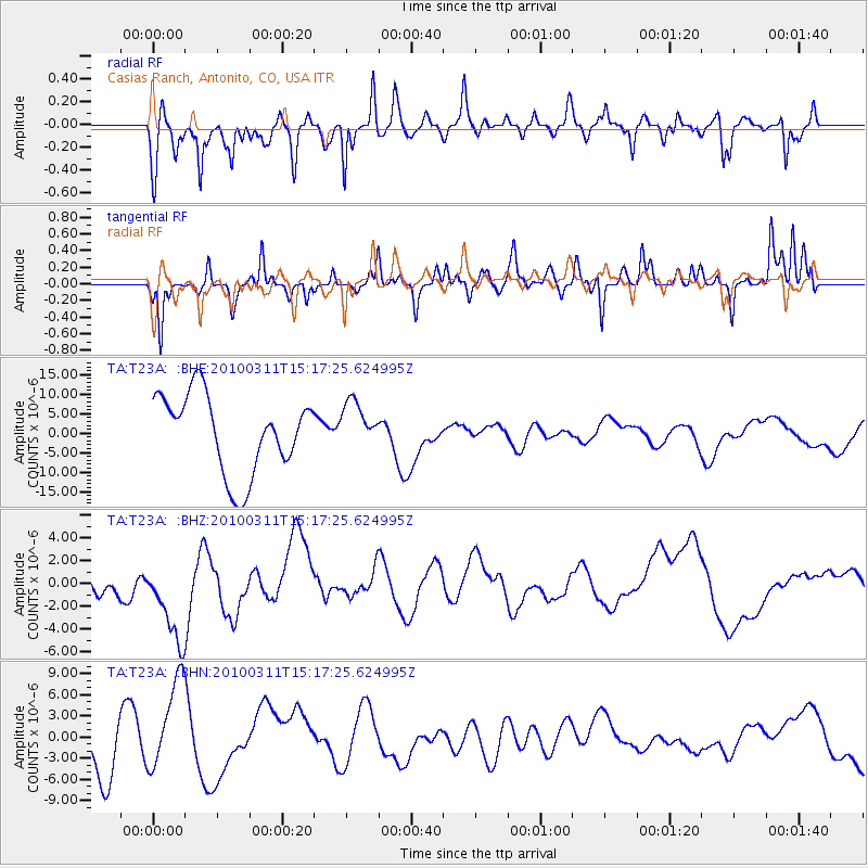
T23A Casias Ranch, Antonito, CO, USA - Earthquake Result Viewer
*The percent match for this event was below the threshold and hence no stack was calculated.
| Earthquake location: |
Near Coast Of Central Chile |
| Earthquake latitude/longitude: |
-34.5/-72.0 |
| Earthquake time(UTC): |
2010/03/11 (070) 15:06:02 GMT |
| Earthquake Depth: |
32 km |
| Earthquake Magnitude: |
6.0 MB, 5.9 ML |
| Earthquake Catalog/Contributor: |
WHDF/NEIC |
|
| Network: |
TA USArray Transportable Network (new EarthScope stations) |
| Station: |
T23A Casias Ranch, Antonito, CO, USA |
| Lat/Lon: |
37.04 N/106.04 W |
| Elevation: |
2429 m |
|
| Distance: |
77.9 deg |
| Az: |
332.738 deg |
| Baz: |
151.775 deg |
| Ray Param: |
$rayparam |
*The percent match for this event was below the threshold and hence was not used in the summary stack. |
|
| Radial Match: |
58.076447 % |
| Radial Bump: |
400 |
| Transverse Match: |
51.079308 % |
| Transverse Bump: |
388 |
| SOD ConfigId: |
299721 |
| Insert Time: |
2010-04-26 23:37:40.324 +0000 |
| GWidth: |
2.5 |
| Max Bumps: |
400 |
| Tol: |
0.001 |
|
Signal To Noise
| Channel | StoN | STA | LTA |
| TA:T23A: :BHZ:20100311T15:17:25.624995Z | 1.7952094 | 3.900121E-6 | 2.172516E-6 |
| TA:T23A: :BHN:20100311T15:17:25.624995Z | 1.0613966 | 6.2138215E-6 | 5.8543824E-6 |
| TA:T23A: :BHE:20100311T15:17:25.624995Z | 0.6119029 | 6.125173E-6 | 1.00100415E-5 |
| Arrivals |
| Ps | |
| PpPs | |
| PsPs/PpSs | |


