You are here: Home > Network List > TA - USArray Transportable Network (new EarthScope stations) Stations List
> Station M24A Cheyenne, WY, USA > Earthquake Result Viewer
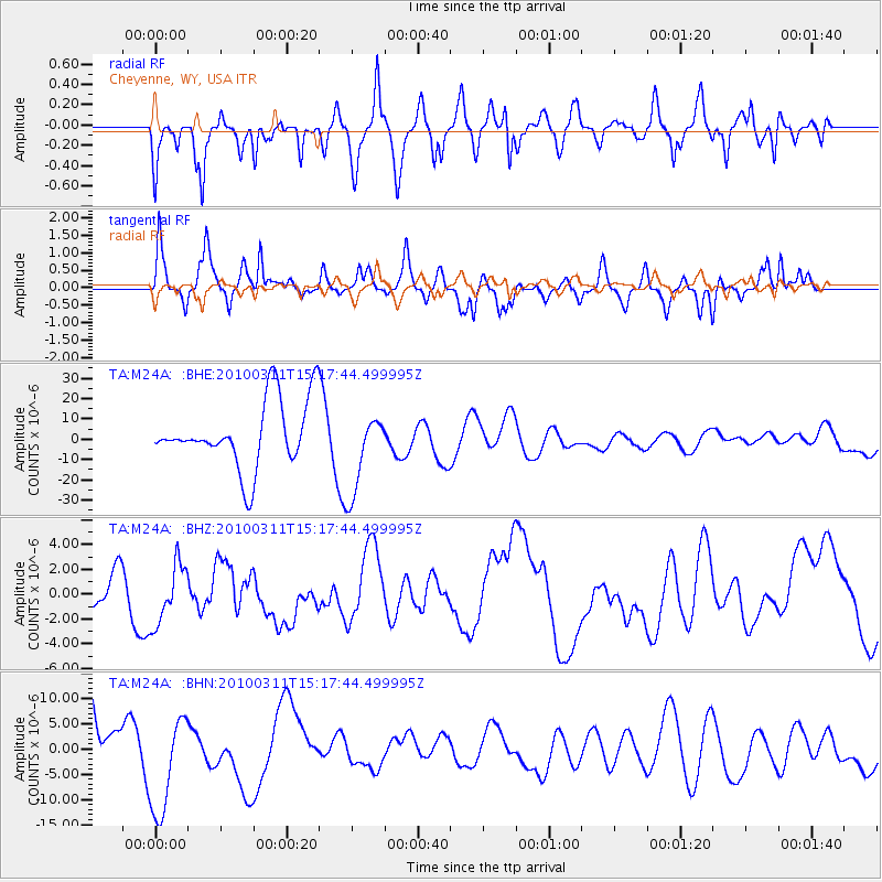
M24A Cheyenne, WY, USA - Earthquake Result Viewer
*The percent match for this event was below the threshold and hence no stack was calculated.
| Earthquake location: |
Near Coast Of Central Chile |
| Earthquake latitude/longitude: |
-34.5/-72.0 |
| Earthquake time(UTC): |
2010/03/11 (070) 15:06:02 GMT |
| Earthquake Depth: |
32 km |
| Earthquake Magnitude: |
6.0 MB, 5.9 ML |
| Earthquake Catalog/Contributor: |
WHDF/NEIC |
|
| Network: |
TA USArray Transportable Network (new EarthScope stations) |
| Station: |
M24A Cheyenne, WY, USA |
| Lat/Lon: |
41.47 N/104.82 W |
| Elevation: |
1816 m |
|
| Distance: |
81.4 deg |
| Az: |
335.669 deg |
| Baz: |
153.068 deg |
| Ray Param: |
$rayparam |
*The percent match for this event was below the threshold and hence was not used in the summary stack. |
|
| Radial Match: |
62.336143 % |
| Radial Bump: |
400 |
| Transverse Match: |
59.320354 % |
| Transverse Bump: |
384 |
| SOD ConfigId: |
299721 |
| Insert Time: |
2010-04-26 23:38:22.122 +0000 |
| GWidth: |
2.5 |
| Max Bumps: |
400 |
| Tol: |
0.001 |
|
Signal To Noise
| Channel | StoN | STA | LTA |
| TA:M24A: :BHZ:20100311T15:17:44.499995Z | 1.1832726 | 2.4153185E-6 | 2.041219E-6 |
| TA:M24A: :BHN:20100311T15:17:44.499995Z | 1.345873 | 1.0228247E-5 | 7.5997127E-6 |
| TA:M24A: :BHE:20100311T15:17:44.499995Z | 1.2396535 | 2.025254E-5 | 1.6337259E-5 |
| Arrivals |
| Ps | |
| PpPs | |
| PsPs/PpSs | |


