You are here: Home > Network List > TA - USArray Transportable Network (new EarthScope stations) Stations List
> Station F21A Absaloka Mine, Hardin, MT, USA > Earthquake Result Viewer
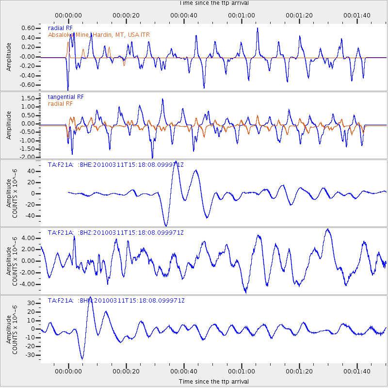
F21A Absaloka Mine, Hardin, MT, USA - Earthquake Result Viewer
*The percent match for this event was below the threshold and hence no stack was calculated.
| Earthquake location: |
Near Coast Of Central Chile |
| Earthquake latitude/longitude: |
-34.5/-72.0 |
| Earthquake time(UTC): |
2010/03/11 (070) 15:06:02 GMT |
| Earthquake Depth: |
32 km |
| Earthquake Magnitude: |
6.0 MB, 5.9 ML |
| Earthquake Catalog/Contributor: |
WHDF/NEIC |
|
| Network: |
TA USArray Transportable Network (new EarthScope stations) |
| Station: |
F21A Absaloka Mine, Hardin, MT, USA |
| Lat/Lon: |
45.82 N/107.12 W |
| Elevation: |
1026 m |
|
| Distance: |
86.0 deg |
| Az: |
336.217 deg |
| Baz: |
151.546 deg |
| Ray Param: |
$rayparam |
*The percent match for this event was below the threshold and hence was not used in the summary stack. |
|
| Radial Match: |
38.739372 % |
| Radial Bump: |
330 |
| Transverse Match: |
35.397934 % |
| Transverse Bump: |
218 |
| SOD ConfigId: |
299721 |
| Insert Time: |
2010-04-26 23:39:57.982 +0000 |
| GWidth: |
2.5 |
| Max Bumps: |
400 |
| Tol: |
0.001 |
|
Signal To Noise
| Channel | StoN | STA | LTA |
| TA:F21A: :BHZ:20100311T15:18:08.099971Z | 0.85361695 | 1.5093984E-6 | 1.7682386E-6 |
| TA:F21A: :BHN:20100311T15:18:08.099971Z | 6.013626 | 1.3665248E-5 | 2.2723807E-6 |
| TA:F21A: :BHE:20100311T15:18:08.099971Z | 12.945073 | 3.1098432E-5 | 2.402337E-6 |
| Arrivals |
| Ps | |
| PpPs | |
| PsPs/PpSs | |


