You are here: Home > Network List > AK - Alaska Regional Network Stations List
> Station C16K Lisburne Hills, AK, USA > Earthquake Result Viewer
C16K Lisburne Hills, AK, USA - Earthquake Result Viewer
| Earthquake location: |
Turkey |
| Earthquake latitude/longitude: |
37.2/37.0 |
| Earthquake time(UTC): |
2023/02/06 (037) 01:17:35 GMT |
| Earthquake Depth: |
18 km |
| Earthquake Magnitude: |
7.8 mww |
| Earthquake Catalog/Contributor: |
NEIC PDE/us |
|
| Network: |
AK Alaska Regional Network |
| Station: |
C16K Lisburne Hills, AK, USA |
| Lat/Lon: |
68.27 N/165.34 W |
| Elevation: |
102 m |
|
| Distance: |
73.5 deg |
| Az: |
8.502 deg |
| Baz: |
341.505 deg |
| Ray Param: |
0.052921303 |
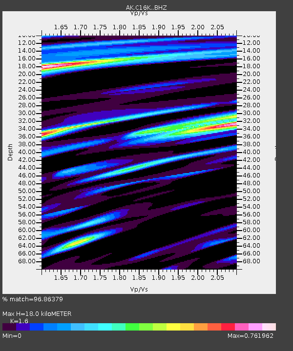
| Estimated Moho Depth: |
18.0 km |
| Estimated Crust Vp/Vs: |
1.60 |
| Assumed Crust Vp: |
5.906 km/s |
| Estimated Crust Vs: |
3.692 km/s |
| Estimated Crust Poisson's Ratio: |
0.18 |
|
| Radial Match: |
96.86379 % |
| Radial Bump: |
363 |
| Transverse Match: |
89.121956 % |
| Transverse Bump: |
400 |
| SOD ConfigId: |
29823551 |
| Insert Time: |
2023-02-20 01:18:36.803 +0000 |
| GWidth: |
2.5 |
| Max Bumps: |
400 |
| Tol: |
0.001 |
|

Signal To Noise
| Channel | StoN | STA | LTA |
| AK:C16K: :BHZ:20230206T01:28:35.980017Z | 3.5159805 | 5.8992515E-7 | 1.6778395E-7 |
| AK:C16K: :BHN:20230206T01:28:35.980017Z | 1.186305 | 2.758102E-7 | 2.324952E-7 |
| AK:C16K: :BHE:20230206T01:28:35.980017Z | 0.7354837 | 1.4285924E-7 | 1.9423848E-7 |
| Arrivals |
| Ps | 1.9 SECOND |
| PpPs | 7.7 SECOND |
| PsPs/PpSs | 9.6 SECOND |


