You are here: Home > Network List > GM - US Geological Survey Networks Stations List
> Station IWM01 Jericho 2M Well Monitoring Station > Earthquake Result Viewer
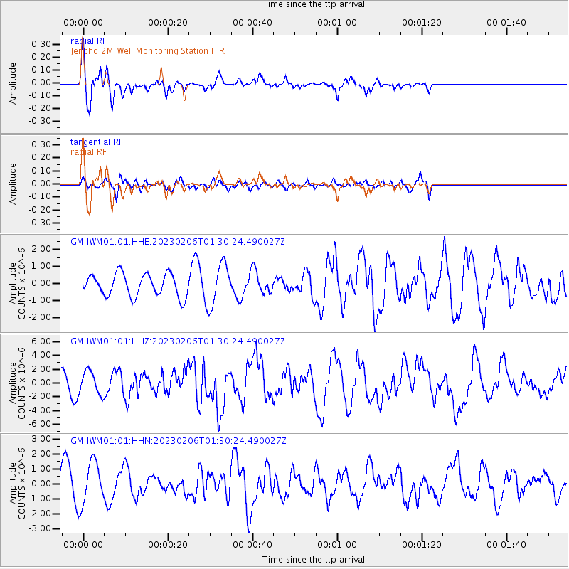
IWM01 Jericho 2M Well Monitoring Station - Earthquake Result Viewer
*The percent match for this event was below the threshold and hence no stack was calculated.
| Earthquake location: |
Turkey |
| Earthquake latitude/longitude: |
37.2/37.0 |
| Earthquake time(UTC): |
2023/02/06 (037) 01:17:35 GMT |
| Earthquake Depth: |
18 km |
| Earthquake Magnitude: |
7.8 mww |
| Earthquake Catalog/Contributor: |
NEIC PDE/us |
|
| Network: |
GM US Geological Survey Networks |
| Station: |
IWM01 Jericho 2M Well Monitoring Station |
| Lat/Lon: |
36.73 N/96.53 W |
| Elevation: |
328 m |
|
| Distance: |
94.8 deg |
| Az: |
324.258 deg |
| Baz: |
35.507 deg |
| Ray Param: |
$rayparam |
*The percent match for this event was below the threshold and hence was not used in the summary stack. |
|
| Radial Match: |
76.460846 % |
| Radial Bump: |
394 |
| Transverse Match: |
68.98652 % |
| Transverse Bump: |
400 |
| SOD ConfigId: |
29823551 |
| Insert Time: |
2023-02-20 01:25:14.557 +0000 |
| GWidth: |
2.5 |
| Max Bumps: |
400 |
| Tol: |
0.001 |
|
Signal To Noise
| Channel | StoN | STA | LTA |
| GM:IWM01:01:HHZ:20230206T01:30:24.490027Z | 2.0412889 | 1.6634662E-6 | 8.149097E-7 |
| GM:IWM01:01:HHN:20230206T01:30:24.490027Z | 1.8723176 | 1.4369649E-6 | 7.6747926E-7 |
| GM:IWM01:01:HHE:20230206T01:30:24.490027Z | 1.9251598 | 1.2585231E-6 | 6.53724E-7 |
| Arrivals |
| Ps | |
| PpPs | |
| PsPs/PpSs | |


