You are here: Home > Network List > IW - Intermountain West Stations List
> Station MOOW Moose Ponds, Wyoming, USA > Earthquake Result Viewer
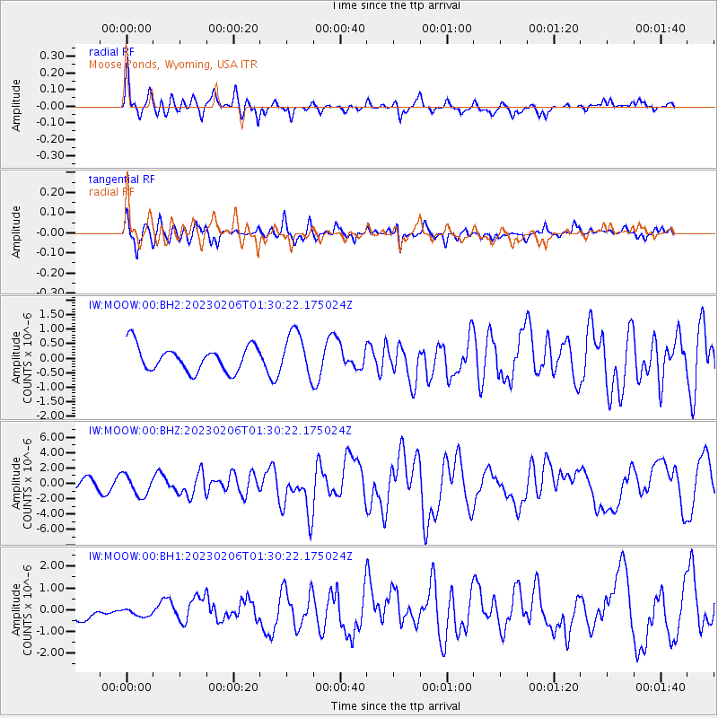
MOOW Moose Ponds, Wyoming, USA - Earthquake Result Viewer
*The percent match for this event was below the threshold and hence no stack was calculated.
| Earthquake location: |
Turkey |
| Earthquake latitude/longitude: |
37.2/37.0 |
| Earthquake time(UTC): |
2023/02/06 (037) 01:17:35 GMT |
| Earthquake Depth: |
18 km |
| Earthquake Magnitude: |
7.8 mww |
| Earthquake Catalog/Contributor: |
NEIC PDE/us |
|
| Network: |
IW Intermountain West |
| Station: |
MOOW Moose Ponds, Wyoming, USA |
| Lat/Lon: |
43.75 N/110.74 W |
| Elevation: |
2128 m |
|
| Distance: |
94.3 deg |
| Az: |
337.206 deg |
| Baz: |
25.28 deg |
| Ray Param: |
$rayparam |
*The percent match for this event was below the threshold and hence was not used in the summary stack. |
|
| Radial Match: |
69.2972 % |
| Radial Bump: |
396 |
| Transverse Match: |
69.87006 % |
| Transverse Bump: |
400 |
| SOD ConfigId: |
29823551 |
| Insert Time: |
2023-02-20 01:26:10.731 +0000 |
| GWidth: |
2.5 |
| Max Bumps: |
400 |
| Tol: |
0.001 |
|
Signal To Noise
| Channel | StoN | STA | LTA |
| IW:MOOW:00:BHZ:20230206T01:30:22.175024Z | 2.5676312 | 1.3169116E-6 | 5.128897E-7 |
| IW:MOOW:00:BH1:20230206T01:30:22.175024Z | 0.3335543 | 2.046072E-7 | 6.1341495E-7 |
| IW:MOOW:00:BH2:20230206T01:30:22.175024Z | 1.7458655 | 7.597208E-7 | 4.3515428E-7 |
| Arrivals |
| Ps | |
| PpPs | |
| PsPs/PpSs | |


