You are here: Home > Network List > TA - USArray Transportable Network (new EarthScope stations) Stations List
> Station G22A Birney, MT, USA > Earthquake Result Viewer
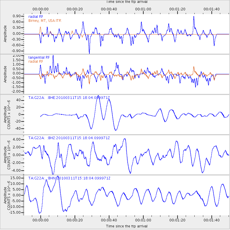
G22A Birney, MT, USA - Earthquake Result Viewer
*The percent match for this event was below the threshold and hence no stack was calculated.
| Earthquake location: |
Near Coast Of Central Chile |
| Earthquake latitude/longitude: |
-34.5/-72.0 |
| Earthquake time(UTC): |
2010/03/11 (070) 15:06:02 GMT |
| Earthquake Depth: |
32 km |
| Earthquake Magnitude: |
6.0 MB, 5.9 ML |
| Earthquake Catalog/Contributor: |
WHDF/NEIC |
|
| Network: |
TA USArray Transportable Network (new EarthScope stations) |
| Station: |
G22A Birney, MT, USA |
| Lat/Lon: |
45.22 N/106.29 W |
| Elevation: |
1203 m |
|
| Distance: |
85.2 deg |
| Az: |
336.448 deg |
| Baz: |
152.155 deg |
| Ray Param: |
$rayparam |
*The percent match for this event was below the threshold and hence was not used in the summary stack. |
|
| Radial Match: |
60.769875 % |
| Radial Bump: |
366 |
| Transverse Match: |
38.561867 % |
| Transverse Bump: |
328 |
| SOD ConfigId: |
299721 |
| Insert Time: |
2010-04-26 23:43:00.702 +0000 |
| GWidth: |
2.5 |
| Max Bumps: |
400 |
| Tol: |
0.001 |
|
Signal To Noise
| Channel | StoN | STA | LTA |
| TA:G22A: :BHZ:20100311T15:18:04.099971Z | 0.9166967 | 1.5896969E-6 | 1.734158E-6 |
| TA:G22A: :BHN:20100311T15:18:04.099971Z | 4.144247 | 1.1256621E-5 | 2.716204E-6 |
| TA:G22A: :BHE:20100311T15:18:04.099971Z | 12.961342 | 3.6913574E-5 | 2.8479747E-6 |
| Arrivals |
| Ps | |
| PpPs | |
| PsPs/PpSs | |


