You are here: Home > Network List > TA - USArray Transportable Network (new EarthScope stations) Stations List
> Station G24A Alzada, MT, USA > Earthquake Result Viewer
G24A Alzada, MT, USA - Earthquake Result Viewer
*The percent match for this event was below the threshold and hence no stack was calculated.
| Earthquake location: |
Near Coast Of Central Chile |
| Earthquake latitude/longitude: |
-34.5/-72.0 |
| Earthquake time(UTC): |
2010/03/11 (070) 15:06:02 GMT |
| Earthquake Depth: |
32 km |
| Earthquake Magnitude: |
6.0 MB, 5.9 ML |
| Earthquake Catalog/Contributor: |
WHDF/NEIC |
|
| Network: |
TA USArray Transportable Network (new EarthScope stations) |
| Station: |
G24A Alzada, MT, USA |
| Lat/Lon: |
45.33 N/104.42 W |
| Elevation: |
1147 m |
|
| Distance: |
84.7 deg |
| Az: |
337.682 deg |
| Baz: |
153.592 deg |
| Ray Param: |
$rayparam |
*The percent match for this event was below the threshold and hence was not used in the summary stack. |
|
| Radial Match: |
44.52163 % |
| Radial Bump: |
246 |
| Transverse Match: |
29.42654 % |
| Transverse Bump: |
242 |
| SOD ConfigId: |
299721 |
| Insert Time: |
2010-04-26 23:43:14.292 +0000 |
| GWidth: |
2.5 |
| Max Bumps: |
400 |
| Tol: |
0.001 |
|
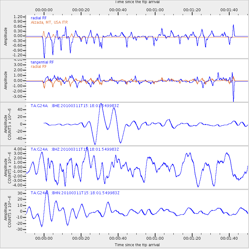
Signal To Noise
| Channel | StoN | STA | LTA |
| TA:G24A: :BHZ:20100311T15:18:01.549983Z | 2.0130918 | 1.6873714E-6 | 8.381989E-7 |
| TA:G24A: :BHN:20100311T15:18:01.549983Z | 6.1766596 | 2.0249927E-5 | 3.2784594E-6 |
| TA:G24A: :BHE:20100311T15:18:01.549983Z | 11.256681 | 3.2036365E-5 | 2.8459865E-6 |
| Arrivals |
| Ps | |
| PpPs | |
| PsPs/PpSs | |


