You are here: Home > Network List > N4 - Central and EAstern US Network Stations List
> Station Q51A Peebles, OH, USA > Earthquake Result Viewer
Q51A Peebles, OH, USA - Earthquake Result Viewer
| Earthquake location: |
Turkey |
| Earthquake latitude/longitude: |
37.2/37.0 |
| Earthquake time(UTC): |
2023/02/06 (037) 01:17:35 GMT |
| Earthquake Depth: |
18 km |
| Earthquake Magnitude: |
7.8 mww |
| Earthquake Catalog/Contributor: |
NEIC PDE/us |
|
| Network: |
N4 Central and EAstern US Network |
| Station: |
Q51A Peebles, OH, USA |
| Lat/Lon: |
39.03 N/83.35 W |
| Elevation: |
362 m |
|
| Distance: |
86.4 deg |
| Az: |
317.683 deg |
| Baz: |
43.665 deg |
| Ray Param: |
0.044054303 |
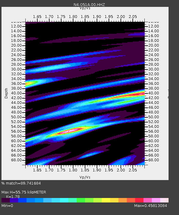
| Estimated Moho Depth: |
55.75 km |
| Estimated Crust Vp/Vs: |
1.78 |
| Assumed Crust Vp: |
6.232 km/s |
| Estimated Crust Vs: |
3.501 km/s |
| Estimated Crust Poisson's Ratio: |
0.27 |
|
| Radial Match: |
89.741684 % |
| Radial Bump: |
228 |
| Transverse Match: |
72.534065 % |
| Transverse Bump: |
400 |
| SOD ConfigId: |
29823551 |
| Insert Time: |
2023-02-20 01:28:12.760 +0000 |
| GWidth: |
2.5 |
| Max Bumps: |
400 |
| Tol: |
0.001 |
|

Signal To Noise
| Channel | StoN | STA | LTA |
| N4:Q51A:00:HHZ:20230206T01:29:45.279028Z | 1.4758278 | 1.0663346E-6 | 7.225332E-7 |
| N4:Q51A:00:HH1:20230206T01:29:45.279028Z | 2.0638354 | 1.3854085E-6 | 6.712786E-7 |
| N4:Q51A:00:HH2:20230206T01:29:45.279028Z | 0.7898372 | 4.3391722E-7 | 5.4937556E-7 |
| Arrivals |
| Ps | 7.1 SECOND |
| PpPs | 24 SECOND |
| PsPs/PpSs | 31 SECOND |


