You are here: Home > Network List > TA - USArray Transportable Network (new EarthScope stations) Stations List
> Station P30A Selden, KS, USA > Earthquake Result Viewer
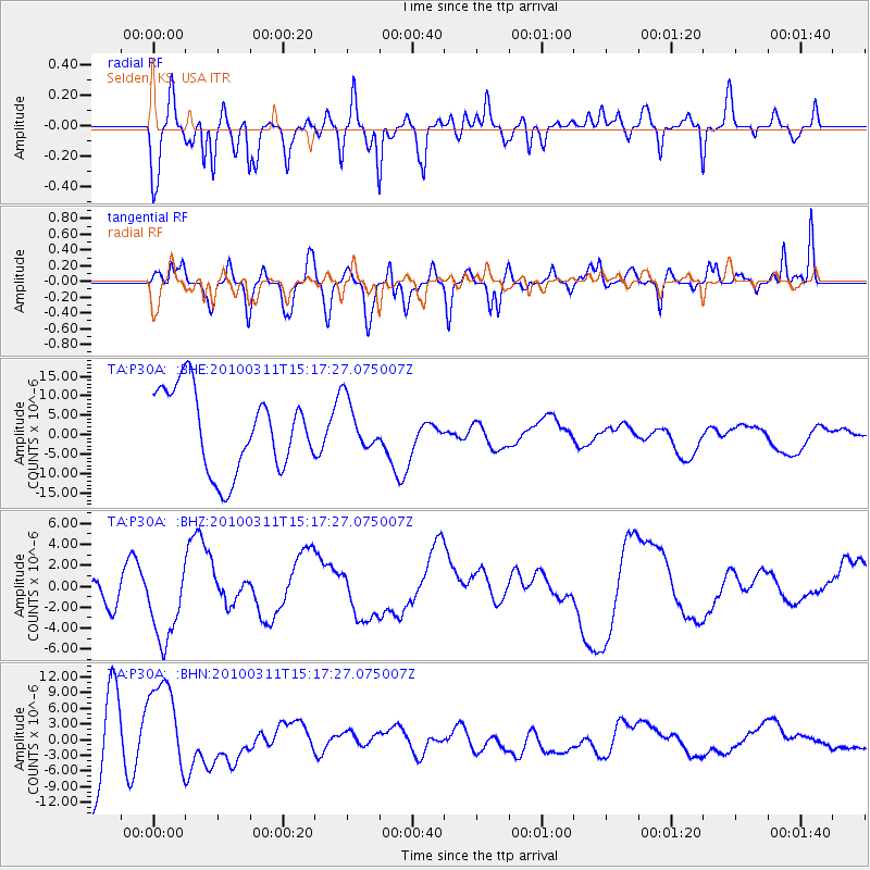
P30A Selden, KS, USA - Earthquake Result Viewer
*The percent match for this event was below the threshold and hence no stack was calculated.
| Earthquake location: |
Near Coast Of Central Chile |
| Earthquake latitude/longitude: |
-34.5/-72.0 |
| Earthquake time(UTC): |
2010/03/11 (070) 15:06:02 GMT |
| Earthquake Depth: |
32 km |
| Earthquake Magnitude: |
6.0 MB, 5.9 ML |
| Earthquake Catalog/Contributor: |
WHDF/NEIC |
|
| Network: |
TA USArray Transportable Network (new EarthScope stations) |
| Station: |
P30A Selden, KS, USA |
| Lat/Lon: |
39.54 N/100.25 W |
| Elevation: |
788 m |
|
| Distance: |
78.1 deg |
| Az: |
338.045 deg |
| Baz: |
156.454 deg |
| Ray Param: |
$rayparam |
*The percent match for this event was below the threshold and hence was not used in the summary stack. |
|
| Radial Match: |
37.9215 % |
| Radial Bump: |
400 |
| Transverse Match: |
29.986864 % |
| Transverse Bump: |
400 |
| SOD ConfigId: |
299721 |
| Insert Time: |
2010-04-26 23:44:41.170 +0000 |
| GWidth: |
2.5 |
| Max Bumps: |
400 |
| Tol: |
0.001 |
|
Signal To Noise
| Channel | StoN | STA | LTA |
| TA:P30A: :BHZ:20100311T15:17:27.075007Z | 1.8521398 | 4.0697228E-6 | 2.1973085E-6 |
| TA:P30A: :BHN:20100311T15:17:27.075007Z | 1.1686589 | 8.540416E-6 | 7.307878E-6 |
| TA:P30A: :BHE:20100311T15:17:27.075007Z | 0.6088966 | 6.275967E-6 | 1.0307114E-5 |
| Arrivals |
| Ps | |
| PpPs | |
| PsPs/PpSs | |


