You are here: Home > Network List > TA - USArray Transportable Network (new EarthScope stations) Stations List
> Station D26A Manning, ND, USA > Earthquake Result Viewer
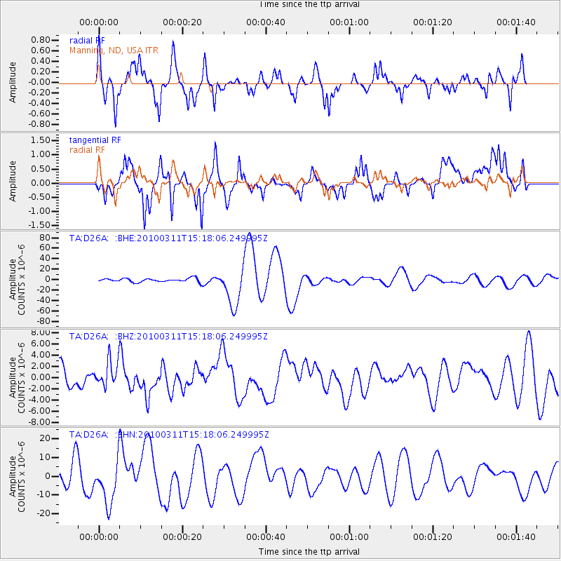
D26A Manning, ND, USA - Earthquake Result Viewer
*The percent match for this event was below the threshold and hence no stack was calculated.
| Earthquake location: |
Near Coast Of Central Chile |
| Earthquake latitude/longitude: |
-34.5/-72.0 |
| Earthquake time(UTC): |
2010/03/11 (070) 15:06:02 GMT |
| Earthquake Depth: |
32 km |
| Earthquake Magnitude: |
6.0 MB, 5.9 ML |
| Earthquake Catalog/Contributor: |
WHDF/NEIC |
|
| Network: |
TA USArray Transportable Network (new EarthScope stations) |
| Station: |
D26A Manning, ND, USA |
| Lat/Lon: |
47.03 N/102.44 W |
| Elevation: |
693 m |
|
| Distance: |
85.6 deg |
| Az: |
339.666 deg |
| Baz: |
155.184 deg |
| Ray Param: |
$rayparam |
*The percent match for this event was below the threshold and hence was not used in the summary stack. |
|
| Radial Match: |
31.92253 % |
| Radial Bump: |
260 |
| Transverse Match: |
29.899721 % |
| Transverse Bump: |
293 |
| SOD ConfigId: |
299721 |
| Insert Time: |
2010-04-26 23:47:39.945 +0000 |
| GWidth: |
2.5 |
| Max Bumps: |
400 |
| Tol: |
0.001 |
|
Signal To Noise
| Channel | StoN | STA | LTA |
| TA:D26A: :BHZ:20100311T15:18:06.249995Z | 1.6584882 | 2.4716364E-6 | 1.4902948E-6 |
| TA:D26A: :BHN:20100311T15:18:06.249995Z | 2.8053434 | 1.206546E-5 | 4.3008854E-6 |
| TA:D26A: :BHE:20100311T15:18:06.249995Z | 10.765714 | 3.8347152E-5 | 3.5619703E-6 |
| Arrivals |
| Ps | |
| PpPs | |
| PsPs/PpSs | |


