You are here: Home > Network List > IU - Global Seismograph Network (GSN - IRIS/USGS) Stations List
> Station PMG Port Moresby, New Guinea > Earthquake Result Viewer
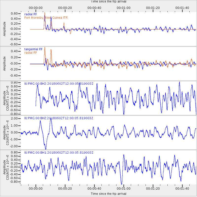
PMG Port Moresby, New Guinea - Earthquake Result Viewer
*The percent match for this event was below the threshold and hence no stack was calculated.
| Earthquake location: |
Samoa Islands Region |
| Earthquake latitude/longitude: |
-14.8/-173.1 |
| Earthquake time(UTC): |
2018/06/02 (153) 11:53:06 GMT |
| Earthquake Depth: |
50 km |
| Earthquake Magnitude: |
5.6 mb |
| Earthquake Catalog/Contributor: |
NEIC PDE/us |
|
| Network: |
IU Global Seismograph Network (GSN - IRIS/USGS) |
| Station: |
PMG Port Moresby, New Guinea |
| Lat/Lon: |
9.40 S/147.16 E |
| Elevation: |
90 m |
|
| Distance: |
39.2 deg |
| Az: |
273.207 deg |
| Baz: |
101.819 deg |
| Ray Param: |
$rayparam |
*The percent match for this event was below the threshold and hence was not used in the summary stack. |
|
| Radial Match: |
75.55603 % |
| Radial Bump: |
400 |
| Transverse Match: |
55.616497 % |
| Transverse Bump: |
400 |
| SOD ConfigId: |
2973751 |
| Insert Time: |
2018-10-09 13:04:12.967 +0000 |
| GWidth: |
2.5 |
| Max Bumps: |
400 |
| Tol: |
0.001 |
|
Signal To Noise
| Channel | StoN | STA | LTA |
| IU:PMG:00:BHZ:20180602T12:00:05.819003Z | 3.8111346 | 6.932355E-7 | 1.818974E-7 |
| IU:PMG:00:BH1:20180602T12:00:05.819003Z | 0.8996499 | 1.7191704E-7 | 1.9109326E-7 |
| IU:PMG:00:BH2:20180602T12:00:05.819003Z | 1.4834137 | 3.9010652E-7 | 2.6297894E-7 |
| Arrivals |
| Ps | |
| PpPs | |
| PsPs/PpSs | |


