You are here: Home > Network List > IU - Global Seismograph Network (GSN - IRIS/USGS) Stations List
> Station RSSD Black Hills, South Dakota, USA > Earthquake Result Viewer
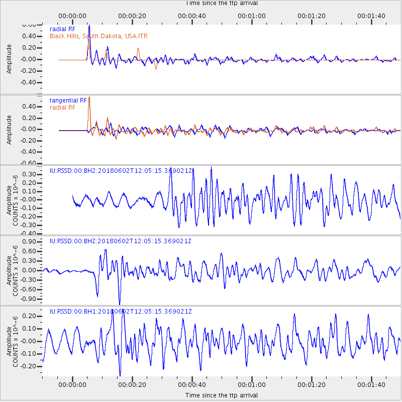
RSSD Black Hills, South Dakota, USA - Earthquake Result Viewer
*The percent match for this event was below the threshold and hence no stack was calculated.
| Earthquake location: |
Samoa Islands Region |
| Earthquake latitude/longitude: |
-14.8/-173.1 |
| Earthquake time(UTC): |
2018/06/02 (153) 11:53:06 GMT |
| Earthquake Depth: |
50 km |
| Earthquake Magnitude: |
5.6 mb |
| Earthquake Catalog/Contributor: |
NEIC PDE/us |
|
| Network: |
IU Global Seismograph Network (GSN - IRIS/USGS) |
| Station: |
RSSD Black Hills, South Dakota, USA |
| Lat/Lon: |
44.12 N/104.04 W |
| Elevation: |
2090 m |
|
| Distance: |
85.8 deg |
| Az: |
42.414 deg |
| Baz: |
244.949 deg |
| Ray Param: |
$rayparam |
*The percent match for this event was below the threshold and hence was not used in the summary stack. |
|
| Radial Match: |
83.54549 % |
| Radial Bump: |
287 |
| Transverse Match: |
69.33428 % |
| Transverse Bump: |
380 |
| SOD ConfigId: |
2973751 |
| Insert Time: |
2018-10-09 13:04:17.190 +0000 |
| GWidth: |
2.5 |
| Max Bumps: |
400 |
| Tol: |
0.001 |
|
Signal To Noise
| Channel | StoN | STA | LTA |
| IU:RSSD:00:BHZ:20180602T12:05:15.369021Z | 0.42065197 | 1.7947894E-8 | 4.2666848E-8 |
| IU:RSSD:00:BH1:20180602T12:05:15.369021Z | 1.0256457 | 7.0253414E-8 | 6.849676E-8 |
| IU:RSSD:00:BH2:20180602T12:05:15.369021Z | 1.1207029 | 5.5070835E-8 | 4.913955E-8 |
| Arrivals |
| Ps | |
| PpPs | |
| PsPs/PpSs | |


