You are here: Home > Network List > N4 - Central and EAstern US Network Stations List
> Station E46A Sault Ste Marie, MI, USA > Earthquake Result Viewer
E46A Sault Ste Marie, MI, USA - Earthquake Result Viewer
| Earthquake location: |
Jordan - Syria Region |
| Earthquake latitude/longitude: |
37.0/36.7 |
| Earthquake time(UTC): |
2023/02/06 (037) 01:36:27 GMT |
| Earthquake Depth: |
10 km |
| Earthquake Magnitude: |
5.6 mb |
| Earthquake Catalog/Contributor: |
NEIC PDE/us |
|
| Network: |
N4 Central and EAstern US Network |
| Station: |
E46A Sault Ste Marie, MI, USA |
| Lat/Lon: |
46.37 N/84.31 W |
| Elevation: |
269 m |
|
| Distance: |
81.6 deg |
| Az: |
323.121 deg |
| Baz: |
43.939 deg |
| Ray Param: |
0.047507577 |
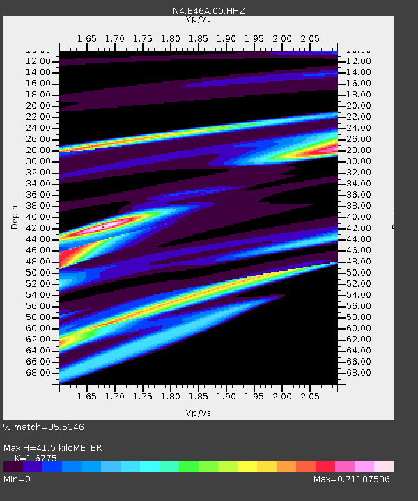
| Estimated Moho Depth: |
41.5 km |
| Estimated Crust Vp/Vs: |
1.68 |
| Assumed Crust Vp: |
6.467 km/s |
| Estimated Crust Vs: |
3.855 km/s |
| Estimated Crust Poisson's Ratio: |
0.22 |
|
| Radial Match: |
85.5346 % |
| Radial Bump: |
309 |
| Transverse Match: |
63.90035 % |
| Transverse Bump: |
159 |
| SOD ConfigId: |
29823551 |
| Insert Time: |
2023-02-20 02:25:22.351 +0000 |
| GWidth: |
2.5 |
| Max Bumps: |
400 |
| Tol: |
0.001 |
|

Signal To Noise
| Channel | StoN | STA | LTA |
| N4:E46A:00:HHZ:20230206T01:48:13.679998Z | 2.897095 | 2.2035645E-5 | 7.6061174E-6 |
| N4:E46A:00:HH1:20230206T01:48:13.679998Z | 0.611697 | 5.2604796E-6 | 8.599813E-6 |
| N4:E46A:00:HH2:20230206T01:48:13.679998Z | 1.447286 | 1.2173038E-5 | 8.4109415E-6 |
| Arrivals |
| Ps | 4.5 SECOND |
| PpPs | 17 SECOND |
| PsPs/PpSs | 21 SECOND |


