You are here: Home > Network List > AG - Arkansas Seismic Network Stations List
> Station XA02 Annieville, Arkansas > Earthquake Result Viewer
XA02 Annieville, Arkansas - Earthquake Result Viewer
| Earthquake location: |
Turkey |
| Earthquake latitude/longitude: |
38.0/37.2 |
| Earthquake time(UTC): |
2023/02/06 (037) 10:24:49 GMT |
| Earthquake Depth: |
10 km |
| Earthquake Magnitude: |
7.5 mww |
| Earthquake Catalog/Contributor: |
NEIC PDE/us |
|
| Network: |
AG Arkansas Seismic Network |
| Station: |
XA02 Annieville, Arkansas |
| Lat/Lon: |
36.16 N/91.26 W |
| Elevation: |
190 m |
|
| Distance: |
92.1 deg |
| Az: |
320.647 deg |
| Baz: |
38.231 deg |
| Ray Param: |
0.04150948 |
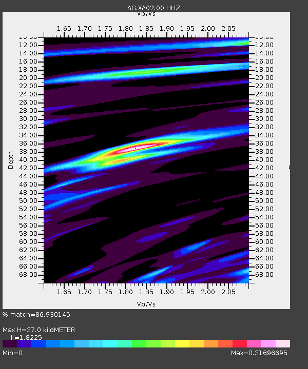
| Estimated Moho Depth: |
37.0 km |
| Estimated Crust Vp/Vs: |
1.82 |
| Assumed Crust Vp: |
6.53 km/s |
| Estimated Crust Vs: |
3.583 km/s |
| Estimated Crust Poisson's Ratio: |
0.28 |
|
| Radial Match: |
86.930145 % |
| Radial Bump: |
370 |
| Transverse Match: |
49.542976 % |
| Transverse Bump: |
400 |
| SOD ConfigId: |
29823551 |
| Insert Time: |
2023-02-20 10:25:59.122 +0000 |
| GWidth: |
2.5 |
| Max Bumps: |
400 |
| Tol: |
0.001 |
|
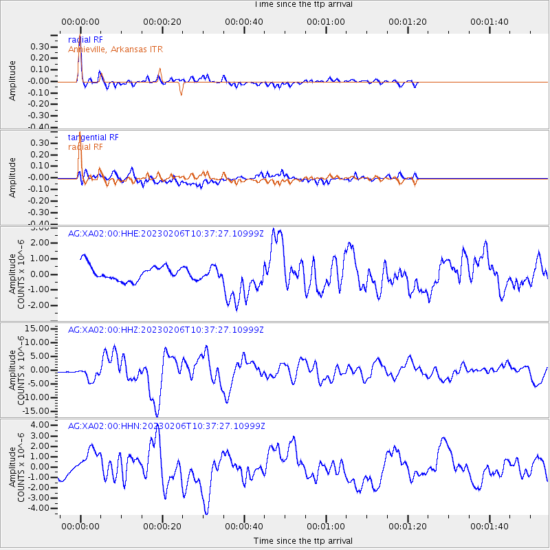
Signal To Noise
| Channel | StoN | STA | LTA |
| AG:XA02:00:HHZ:20230206T10:37:27.10999Z | 8.767985 | 2.3923135E-6 | 2.7284642E-7 |
| AG:XA02:00:HHN:20230206T10:37:27.10999Z | 2.257909 | 1.5762447E-6 | 6.9809926E-7 |
| AG:XA02:00:HHE:20230206T10:37:27.10999Z | 0.69224024 | 3.3244928E-7 | 4.802513E-7 |
| Arrivals |
| Ps | 4.8 SECOND |
| PpPs | 16 SECOND |
| PsPs/PpSs | 20 SECOND |


