You are here: Home > Network List > AK - Alaska Regional Network Stations List
> Station M27K Edge Creek, AK, USA > Earthquake Result Viewer
M27K Edge Creek, AK, USA - Earthquake Result Viewer
| Earthquake location: |
Turkey |
| Earthquake latitude/longitude: |
38.0/37.2 |
| Earthquake time(UTC): |
2023/02/06 (037) 10:24:49 GMT |
| Earthquake Depth: |
10 km |
| Earthquake Magnitude: |
7.5 mww |
| Earthquake Catalog/Contributor: |
NEIC PDE/us |
|
| Network: |
AK Alaska Regional Network |
| Station: |
M27K Edge Creek, AK, USA |
| Lat/Lon: |
62.36 N/141.88 W |
| Elevation: |
1536 m |
|
| Distance: |
80.0 deg |
| Az: |
359.565 deg |
| Baz: |
0.737 deg |
| Ray Param: |
0.04860965 |
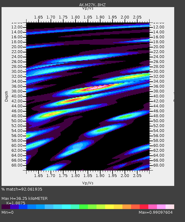
| Estimated Moho Depth: |
36.25 km |
| Estimated Crust Vp/Vs: |
1.89 |
| Assumed Crust Vp: |
6.566 km/s |
| Estimated Crust Vs: |
3.479 km/s |
| Estimated Crust Poisson's Ratio: |
0.30 |
|
| Radial Match: |
92.061935 % |
| Radial Bump: |
400 |
| Transverse Match: |
80.692406 % |
| Transverse Bump: |
400 |
| SOD ConfigId: |
29823551 |
| Insert Time: |
2023-02-20 10:28:02.239 +0000 |
| GWidth: |
2.5 |
| Max Bumps: |
400 |
| Tol: |
0.001 |
|

Signal To Noise
| Channel | StoN | STA | LTA |
| AK:M27K: :BHZ:20230206T10:36:27.060002Z | 4.1949654 | 2.879521E-6 | 6.8642305E-7 |
| AK:M27K: :BHN:20230206T10:36:27.060002Z | 1.8206717 | 1.5358135E-6 | 8.4354224E-7 |
| AK:M27K: :BHE:20230206T10:36:27.060002Z | 2.1886578 | 1.2580384E-6 | 5.7479906E-7 |
| Arrivals |
| Ps | 5.0 SECOND |
| PpPs | 16 SECOND |
| PsPs/PpSs | 21 SECOND |


