You are here: Home > Network List > AK - Alaska Regional Network Stations List
> Station P17K Kvichak River, AK, USA > Earthquake Result Viewer
P17K Kvichak River, AK, USA - Earthquake Result Viewer
| Earthquake location: |
Turkey |
| Earthquake latitude/longitude: |
38.0/37.2 |
| Earthquake time(UTC): |
2023/02/06 (037) 10:24:49 GMT |
| Earthquake Depth: |
10 km |
| Earthquake Magnitude: |
7.5 mww |
| Earthquake Catalog/Contributor: |
NEIC PDE/us |
|
| Network: |
AK Alaska Regional Network |
| Station: |
P17K Kvichak River, AK, USA |
| Lat/Lon: |
59.20 N/156.44 W |
| Elevation: |
91 m |
|
| Distance: |
82.5 deg |
| Az: |
7.033 deg |
| Baz: |
349.17 deg |
| Ray Param: |
0.046862695 |
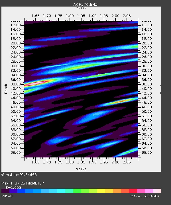
| Estimated Moho Depth: |
37.25 km |
| Estimated Crust Vp/Vs: |
1.65 |
| Assumed Crust Vp: |
6.276 km/s |
| Estimated Crust Vs: |
3.792 km/s |
| Estimated Crust Poisson's Ratio: |
0.21 |
|
| Radial Match: |
91.54668 % |
| Radial Bump: |
400 |
| Transverse Match: |
79.22429 % |
| Transverse Bump: |
400 |
| SOD ConfigId: |
29823551 |
| Insert Time: |
2023-02-20 10:28:24.321 +0000 |
| GWidth: |
2.5 |
| Max Bumps: |
400 |
| Tol: |
0.001 |
|

Signal To Noise
| Channel | StoN | STA | LTA |
| AK:P17K: :BHZ:20230206T10:36:40.380009Z | 6.30631 | 3.901217E-6 | 6.186212E-7 |
| AK:P17K: :BHN:20230206T10:36:40.380009Z | 2.1847289 | 3.145756E-6 | 1.4398839E-6 |
| AK:P17K: :BHE:20230206T10:36:40.380009Z | 0.97991395 | 1.5979715E-6 | 1.6307264E-6 |
| Arrivals |
| Ps | 4.0 SECOND |
| PpPs | 15 SECOND |
| PsPs/PpSs | 19 SECOND |


