You are here: Home > Network List > US - United States National Seismic Network Stations List
> Station AMTX Amarillo, Texas, USA > Earthquake Result Viewer
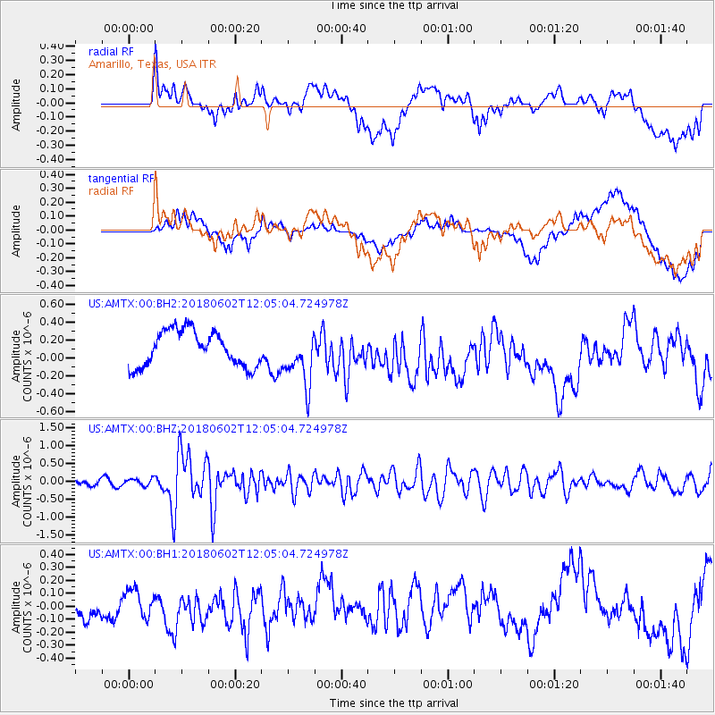
AMTX Amarillo, Texas, USA - Earthquake Result Viewer
*The percent match for this event was below the threshold and hence no stack was calculated.
| Earthquake location: |
Samoa Islands Region |
| Earthquake latitude/longitude: |
-14.8/-173.1 |
| Earthquake time(UTC): |
2018/06/02 (153) 11:53:06 GMT |
| Earthquake Depth: |
50 km |
| Earthquake Magnitude: |
5.6 mb |
| Earthquake Catalog/Contributor: |
NEIC PDE/us |
|
| Network: |
US United States National Seismic Network |
| Station: |
AMTX Amarillo, Texas, USA |
| Lat/Lon: |
34.53 N/101.41 W |
| Elevation: |
1010 m |
|
| Distance: |
83.8 deg |
| Az: |
52.039 deg |
| Baz: |
247.485 deg |
| Ray Param: |
$rayparam |
*The percent match for this event was below the threshold and hence was not used in the summary stack. |
|
| Radial Match: |
54.39027 % |
| Radial Bump: |
400 |
| Transverse Match: |
48.612732 % |
| Transverse Bump: |
400 |
| SOD ConfigId: |
2973751 |
| Insert Time: |
2018-10-09 13:06:43.243 +0000 |
| GWidth: |
2.5 |
| Max Bumps: |
400 |
| Tol: |
0.001 |
|
Signal To Noise
| Channel | StoN | STA | LTA |
| US:AMTX:00:BHZ:20180602T12:05:04.724978Z | 1.1799141 | 9.819879E-8 | 8.322537E-8 |
| US:AMTX:00:BH1:20180602T12:05:04.724978Z | 0.6724975 | 1.0411507E-7 | 1.5481852E-7 |
| US:AMTX:00:BH2:20180602T12:05:04.724978Z | 1.5003915 | 2.8002026E-7 | 1.8663148E-7 |
| Arrivals |
| Ps | |
| PpPs | |
| PsPs/PpSs | |


