You are here: Home > Network List > CC - Cascade Chain Volcano Monitoring Stations List
> Station PR02 Puyallup River 02 > Earthquake Result Viewer
PR02 Puyallup River 02 - Earthquake Result Viewer
| Earthquake location: |
Turkey |
| Earthquake latitude/longitude: |
38.0/37.2 |
| Earthquake time(UTC): |
2023/02/06 (037) 10:24:49 GMT |
| Earthquake Depth: |
10 km |
| Earthquake Magnitude: |
7.5 mww |
| Earthquake Catalog/Contributor: |
NEIC PDE/us |
|
| Network: |
CC Cascade Chain Volcano Monitoring |
| Station: |
PR02 Puyallup River 02 |
| Lat/Lon: |
46.92 N/122.05 W |
| Elevation: |
461 m |
|
| Distance: |
93.4 deg |
| Az: |
345.92 deg |
| Baz: |
16.277 deg |
| Ray Param: |
0.041271802 |
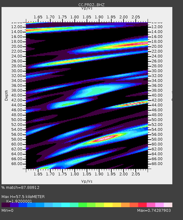
| Estimated Moho Depth: |
57.5 km |
| Estimated Crust Vp/Vs: |
1.92 |
| Assumed Crust Vp: |
6.566 km/s |
| Estimated Crust Vs: |
3.42 km/s |
| Estimated Crust Poisson's Ratio: |
0.31 |
|
| Radial Match: |
87.88912 % |
| Radial Bump: |
400 |
| Transverse Match: |
75.45074 % |
| Transverse Bump: |
400 |
| SOD ConfigId: |
29823551 |
| Insert Time: |
2023-02-20 10:33:43.547 +0000 |
| GWidth: |
2.5 |
| Max Bumps: |
400 |
| Tol: |
0.001 |
|

Signal To Noise
| Channel | StoN | STA | LTA |
| CC:PR02: :BHZ:20230206T10:37:33.039982Z | 3.2292883 | 1.839932E-6 | 5.697639E-7 |
| CC:PR02: :BHN:20230206T10:37:33.039982Z | 1.0368657 | 5.1401884E-7 | 4.957429E-7 |
| CC:PR02: :BHE:20230206T10:37:33.039982Z | 1.7785388 | 1.5167773E-6 | 8.5282215E-7 |
| Arrivals |
| Ps | 8.2 SECOND |
| PpPs | 25 SECOND |
| PsPs/PpSs | 33 SECOND |


