You are here: Home > Network List > CO - South Carolina Seismic Network Stations List
> Station PAULI CO:PAULI > Earthquake Result Viewer
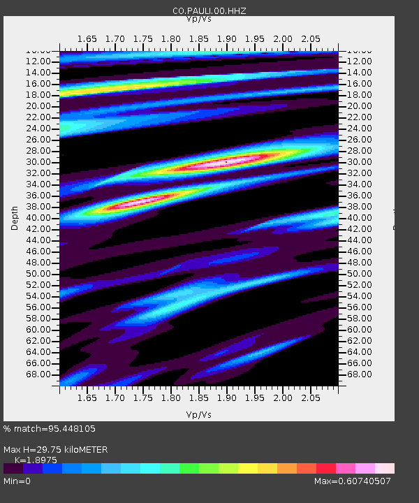
PAULI CO:PAULI - Earthquake Result Viewer
| Earthquake location: |
Turkey |
| Earthquake latitude/longitude: |
38.0/37.2 |
| Earthquake time(UTC): |
2023/02/06 (037) 10:24:49 GMT |
| Earthquake Depth: |
10 km |
| Earthquake Magnitude: |
7.5 mww |
| Earthquake Catalog/Contributor: |
NEIC PDE/us |
|
| Network: |
CO South Carolina Seismic Network |
| Station: |
PAULI CO:PAULI |
| Lat/Lon: |
34.82 N/81.81 W |
| Elevation: |
179 m |
|
| Distance: |
88.1 deg |
| Az: |
313.957 deg |
| Baz: |
43.71 deg |
| Ray Param: |
0.042855393 |
| Estimated Moho Depth: |
29.75 km |
| Estimated Crust Vp/Vs: |
1.90 |
| Assumed Crust Vp: |
6.419 km/s |
| Estimated Crust Vs: |
3.383 km/s |
| Estimated Crust Poisson's Ratio: |
0.31 |
|
| Radial Match: |
95.448105 % |
| Radial Bump: |
215 |
| Transverse Match: |
80.25994 % |
| Transverse Bump: |
400 |
| SOD ConfigId: |
29823551 |
| Insert Time: |
2023-02-20 10:37:25.392 +0000 |
| GWidth: |
2.5 |
| Max Bumps: |
400 |
| Tol: |
0.001 |
|

Signal To Noise
| Channel | StoN | STA | LTA |
| CO:PAULI:00:HHZ:20230206T10:37:08.289982Z | 10.720554 | 5.574711E-6 | 5.200021E-7 |
| CO:PAULI:00:HHN:20230206T10:37:08.289982Z | 5.4333315 | 1.3869827E-6 | 2.55273E-7 |
| CO:PAULI:00:HHE:20230206T10:37:08.289982Z | 2.879423 | 1.3535902E-6 | 4.7009078E-7 |
| Arrivals |
| Ps | 4.2 SECOND |
| PpPs | 13 SECOND |
| PsPs/PpSs | 17 SECOND |


