You are here: Home > Network List > EI - Irish National Seismic Network (INSN) Stations List
> Station IDGL INCH ISLAND, CO DONEGAL, IRELAND > Earthquake Result Viewer
IDGL INCH ISLAND, CO DONEGAL, IRELAND - Earthquake Result Viewer
| Earthquake location: |
Turkey |
| Earthquake latitude/longitude: |
38.0/37.2 |
| Earthquake time(UTC): |
2023/02/06 (037) 10:24:49 GMT |
| Earthquake Depth: |
10 km |
| Earthquake Magnitude: |
7.5 mww |
| Earthquake Catalog/Contributor: |
NEIC PDE/us |
|
| Network: |
EI Irish National Seismic Network (INSN) |
| Station: |
IDGL INCH ISLAND, CO DONEGAL, IRELAND |
| Lat/Lon: |
55.07 N/7.51 W |
| Elevation: |
123 m |
|
| Distance: |
34.5 deg |
| Az: |
314.337 deg |
| Baz: |
100.835 deg |
| Ray Param: |
0.07773887 |
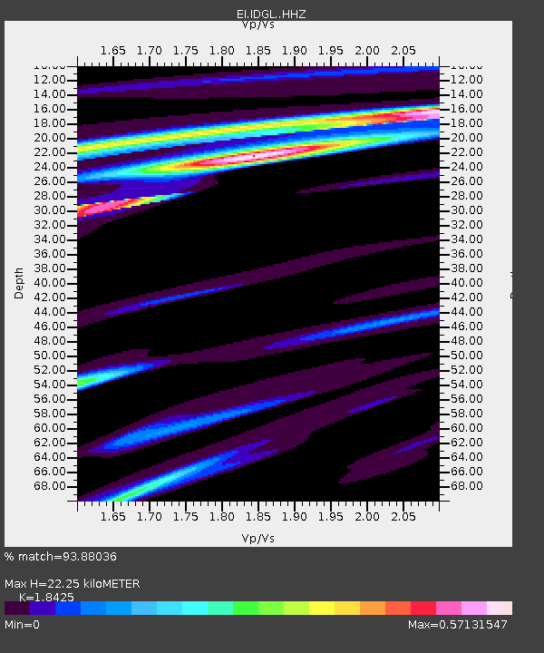
| Estimated Moho Depth: |
22.25 km |
| Estimated Crust Vp/Vs: |
1.84 |
| Assumed Crust Vp: |
6.276 km/s |
| Estimated Crust Vs: |
3.406 km/s |
| Estimated Crust Poisson's Ratio: |
0.29 |
|
| Radial Match: |
93.88036 % |
| Radial Bump: |
196 |
| Transverse Match: |
66.8845 % |
| Transverse Bump: |
400 |
| SOD ConfigId: |
29823551 |
| Insert Time: |
2023-02-20 10:38:03.131 +0000 |
| GWidth: |
2.5 |
| Max Bumps: |
400 |
| Tol: |
0.001 |
|

Signal To Noise
| Channel | StoN | STA | LTA |
| EI:IDGL: :HHZ:20230206T10:31:06.229985Z | 8.428626 | 1.1354817E-5 | 1.347173E-6 |
| EI:IDGL: :HHN:20230206T10:31:06.229985Z | 1.5663657 | 2.2450872E-6 | 1.4333098E-6 |
| EI:IDGL: :HHE:20230206T10:31:06.229985Z | 7.190223 | 9.101647E-6 | 1.2658365E-6 |
| Arrivals |
| Ps | 3.2 SECOND |
| PpPs | 9.4 SECOND |
| PsPs/PpSs | 13 SECOND |


