You are here: Home > Network List > MB - Montana Regional Seismic Network Stations List
> Station BUT Butte, Montana > Earthquake Result Viewer
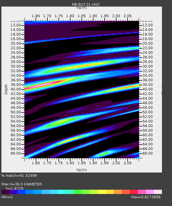
BUT Butte, Montana - Earthquake Result Viewer
| Earthquake location: |
Turkey |
| Earthquake latitude/longitude: |
38.0/37.2 |
| Earthquake time(UTC): |
2023/02/06 (037) 10:24:49 GMT |
| Earthquake Depth: |
10 km |
| Earthquake Magnitude: |
7.5 mww |
| Earthquake Catalog/Contributor: |
NEIC PDE/us |
|
| Network: |
MB Montana Regional Seismic Network |
| Station: |
BUT Butte, Montana |
| Lat/Lon: |
46.01 N/112.56 W |
| Elevation: |
1758 m |
|
| Distance: |
92.0 deg |
| Az: |
339.438 deg |
| Baz: |
23.453 deg |
| Ray Param: |
0.041523077 |
| Estimated Moho Depth: |
38.0 km |
| Estimated Crust Vp/Vs: |
1.67 |
| Assumed Crust Vp: |
6.353 km/s |
| Estimated Crust Vs: |
3.799 km/s |
| Estimated Crust Poisson's Ratio: |
0.22 |
|
| Radial Match: |
91.52499 % |
| Radial Bump: |
400 |
| Transverse Match: |
63.909855 % |
| Transverse Bump: |
400 |
| SOD ConfigId: |
29823551 |
| Insert Time: |
2023-02-20 10:42:14.575 +0000 |
| GWidth: |
2.5 |
| Max Bumps: |
400 |
| Tol: |
0.001 |
|

Signal To Noise
| Channel | StoN | STA | LTA |
| MB:BUT:01:HHZ:20230206T10:37:26.710026Z | 5.09525 | 3.5089706E-6 | 6.8867485E-7 |
| MB:BUT:01:HHN:20230206T10:37:26.710026Z | 2.2360919 | 9.4329124E-7 | 4.2184817E-7 |
| MB:BUT:01:HHE:20230206T10:37:26.710026Z | 0.7769021 | 7.6060934E-7 | 9.790286E-7 |
| Arrivals |
| Ps | 4.1 SECOND |
| PpPs | 16 SECOND |
| PsPs/PpSs | 20 SECOND |


