You are here: Home > Network List > MB - Montana Regional Seismic Network Stations List
> Station FCMT Ford Creek > Earthquake Result Viewer
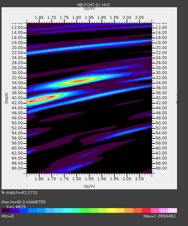
FCMT Ford Creek - Earthquake Result Viewer
| Earthquake location: |
Turkey |
| Earthquake latitude/longitude: |
38.0/37.2 |
| Earthquake time(UTC): |
2023/02/06 (037) 10:24:49 GMT |
| Earthquake Depth: |
10 km |
| Earthquake Magnitude: |
7.5 mww |
| Earthquake Catalog/Contributor: |
NEIC PDE/us |
|
| Network: |
MB Montana Regional Seismic Network |
| Station: |
FCMT Ford Creek |
| Lat/Lon: |
46.46 N/110.86 W |
| Elevation: |
1836 m |
|
| Distance: |
91.1 deg |
| Az: |
338.545 deg |
| Baz: |
24.701 deg |
| Ray Param: |
0.041641284 |
| Estimated Moho Depth: |
40.0 km |
| Estimated Crust Vp/Vs: |
1.66 |
| Assumed Crust Vp: |
6.306 km/s |
| Estimated Crust Vs: |
3.793 km/s |
| Estimated Crust Poisson's Ratio: |
0.22 |
|
| Radial Match: |
92.0731 % |
| Radial Bump: |
400 |
| Transverse Match: |
83.41235 % |
| Transverse Bump: |
400 |
| SOD ConfigId: |
29823551 |
| Insert Time: |
2023-02-20 10:42:17.666 +0000 |
| GWidth: |
2.5 |
| Max Bumps: |
400 |
| Tol: |
0.001 |
|

Signal To Noise
| Channel | StoN | STA | LTA |
| MB:FCMT:01:HHZ:20230206T10:37:22.58997Z | 6.611782 | 2.1032336E-6 | 3.1810387E-7 |
| MB:FCMT:01:HHN:20230206T10:37:22.58997Z | 3.2508423 | 5.807981E-7 | 1.786608E-7 |
| MB:FCMT:01:HHE:20230206T10:37:22.58997Z | 1.854947 | 4.3046515E-7 | 2.3206333E-7 |
| Arrivals |
| Ps | 4.3 SECOND |
| PpPs | 17 SECOND |
| PsPs/PpSs | 21 SECOND |


